
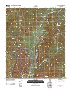
~ Alchesay Flat AZ topo map, 1:24000 scale, 7.5 X 7.5 Minute, Historical, 2011
Alchesay Flat, Arizona, USGS topographic map dated 2011.
Includes geographic coordinates (latitude and longitude). This topographic map is suitable for hiking, camping, and exploring, or framing it as a wall map.
Printed on-demand using high resolution imagery, on heavy weight and acid free paper, or alternatively on a variety of synthetic materials.
Topos available on paper, Waterproof, Poly, or Tyvek. Usually shipping rolled, unless combined with other folded maps in one order.
- Product Number: USGS-5543370
- Free digital map download (high-resolution, GeoPDF): Alchesay Flat, Arizona (file size: 28 MB)
- Map Size: please refer to the dimensions of the GeoPDF map above
- Weight (paper map): ca. 55 grams
- Map Type: POD USGS Topographic Map
- Map Series: US Topo
- Map Verison: Historical
- Cell ID: 448
- Datum: North American Datum of 1983
- Map Projection: Transverse Mercator
- Map Cell Name: Alchesay Flat
- Grid size: 7.5 X 7.5 Minute
- Date on map: 2011
- Map Scale: 1:24000
- Geographical region: Arizona, United States
Neighboring Maps:
All neighboring USGS topo maps are available for sale online at a variety of scales.
Spatial coverage:
Topo map Alchesay Flat, Arizona, covers the geographical area associated the following places:
- Gla She Spring - Chief Alchesay Baha Grave - Divide Tank - Post Office Farms - Sunset Pass Spring - Roberts Ranch - Black Canyon - Pit Tank - Diamond Creek Junction Campground - Rip Rap Tank - Alchesay Springs Campground - Diamond Creek Number Two Campground - Round Top Wash - Pine Creek - Baha Spring - Whitetail Tank - Cliff Tank - Alchesay Tank - Alchesay Flat - Log Tank - Sunset Pass Tank - Bull Creek - Miner Flat - Yellow Jacket Spring - A-ninetyone Spring - Bourke Tank - Bear Flat Creek - Alchesay National Fish Hatchery - Diamond Creek - Columbine Spring - Gold Gulch - Holding Pasture Tank - Baha Spring Number Two - Diamond Creek Community Center - Bull Creek Tank - Cedar Spring - Crocker Spring - Salt Trap Tank - Little Round Top Mountain - Post Office Tank - Baha Ranch - Bull Pasture Tank - Gold Butte - Little Round Top Tank - Cottonwood Canyon - Diamond Tank - Baha Tank - Post Office Canyon - Baha Diversion Dam - North Fork Census Designated Place - Public Health Services Indian Hospital Whiteriver Service Unit - Lower Log Road Campground - Goklish Canyon - Kaytoggie Diversion Dam - Bear Spring
- Map Area ID: AREA3433.875-110-109.875
- Northwest corner Lat/Long code: USGSNW34-110
- Northeast corner Lat/Long code: USGSNE34-109.875
- Southwest corner Lat/Long code: USGSSW33.875-110
- Southeast corner Lat/Long code: USGSSE33.875-109.875
- Northern map edge Latitude: 34
- Southern map edge Latitude: 33.875
- Western map edge Longitude: -110
- Eastern map edge Longitude: -109.875


