
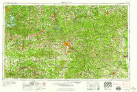
~ Phenix City AL topo map, 1:250000 scale, 1 X 2 Degree, Historical, 1958, updated 1958
Phenix City, Alabama, USGS topographic map dated 1958.
Includes geographic coordinates (latitude and longitude). This topographic map is suitable for hiking, camping, and exploring, or framing it as a wall map.
Printed on-demand using high resolution imagery, on heavy weight and acid free paper, or alternatively on a variety of synthetic materials.
Topos available on paper, Waterproof, Poly, or Tyvek. Usually shipping rolled, unless combined with other folded maps in one order.
- Product Number: USGS-5542915
- Free digital map download (high-resolution, GeoPDF): Phenix City, Alabama (file size: 25 MB)
- Map Size: please refer to the dimensions of the GeoPDF map above
- Weight (paper map): ca. 55 grams
- Map Type: POD USGS Topographic Map
- Map Series: HTMC
- Map Verison: Historical
- Cell ID: 68958
- Scan ID: 305931
- Imprint Year: 1958
- Woodland Tint: Yes
- Field Check Year: 1955
- Datum: Unstated
- Map Projection: Transverse Mercator
- Map published by United States Army Corps of Engineers
- Map published by United States Army
- Map Language: English
- Scanner Resolution: 600 dpi
- Map Cell Name: Phenix City
- Grid size: 1 X 2 Degree
- Date on map: 1958
- Map Scale: 1:250000
- Geographical region: Alabama, United States
Neighboring Maps:
All neighboring USGS topo maps are available for sale online at a variety of scales.
Spatial coverage:
Topo map Phenix City, Alabama, covers the geographical area associated the following places:
- Crystal Valley - Sardis - Beech Springs - Atwater - Chehaw - Heineburg Village (historical) - Five Points - Sherwood Forest - Dimon Woods - Hector - Willow Bend - Edgewood Terrace - Charles - Hearthstone - Carter Acres - Griffen Mill - Rocky Brook - Whitesville - Columbus - Oak Grove - Fitzpatrick - Weems Valley - Beatrice - Walls Crossing - Cedar Hills - Florence - Pleasant Grove - Bruceville - Valley Hills - Brookhaven - Moorefield - Bullochville (historical) - Everglade - Foxfire - Bulloch Crossroads - Five Points - Auburn - Tax Crossroads - Liberty Crossroads - County Line - Oakfuskee (historical) - Omaha - Southland - Langdale - Francisville - Almeria - Buena Vista - Three Notch - Edgewood - Dudleyville - Uchee - Bama Park - Battle Park - Hilyer - Little Texas - Phenix City - Hoggs (historical) - Hopewell - Leesburg - Beallwoods - Denver - Redbone Crossroads - Pinewood - Lafayette - Mount Jefferson - Musella - Christopher - Westfield - Regency Park - Brownsand - Comer - McDaniel Manor - Sardis - Lamar - Old Chimney - Ranch Forest - Harwell Hills - Jacksons Gap - Woodland - Ponders - Fox Chapel - Booker Washington Heights - Bread Tray Hill - Spinks - Holiday Park - Hyram - Brickyard - Andrews Crossroads - Elkahatchee Park - Highland Pines - Nelson - Beauregard - Fairmount (historical) - Hawkins Crossroads - Arrowhead Estates - Berginville - Saint Marys Hills - Ladonia - Sears Woods - Sessions
- Map Area ID: AREA3332-86-84
- Northwest corner Lat/Long code: USGSNW33-86
- Northeast corner Lat/Long code: USGSNE33-84
- Southwest corner Lat/Long code: USGSSW32-86
- Southeast corner Lat/Long code: USGSSE32-84
- Northern map edge Latitude: 33
- Southern map edge Latitude: 32
- Western map edge Longitude: -86
- Eastern map edge Longitude: -84


