
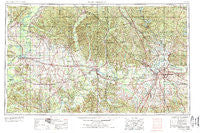
~ Montgomery AL topo map, 1:250000 scale, 1 X 2 Degree, Historical, 1953, updated 1978
Montgomery, Alabama, USGS topographic map dated 1953.
Includes geographic coordinates (latitude and longitude). This topographic map is suitable for hiking, camping, and exploring, or framing it as a wall map.
Printed on-demand using high resolution imagery, on heavy weight and acid free paper, or alternatively on a variety of synthetic materials.
Topos available on paper, Waterproof, Poly, or Tyvek. Usually shipping rolled, unless combined with other folded maps in one order.
- Product Number: USGS-5542913
- Free digital map download (high-resolution, GeoPDF): Montgomery, Alabama (file size: 24 MB)
- Map Size: please refer to the dimensions of the GeoPDF map above
- Weight (paper map): ca. 55 grams
- Map Type: POD USGS Topographic Map
- Map Series: HTMC
- Map Verison: Historical
- Cell ID: 68918
- Scan ID: 305930
- Imprint Year: 1978
- Woodland Tint: Yes
- Visual Version Number: 1
- Aerial Photo Year: 1952
- Edit Year: 1969
- Field Check Year: 1953
- Datum: Unstated
- Map Projection: Transverse Mercator
- Map published by United States Geological Survey
- Map published by: Military, Other
- Map Language: English
- Scanner Resolution: 600 dpi
- Map Cell Name: Montgomery
- Grid size: 1 X 2 Degree
- Date on map: 1953
- Map Scale: 1:250000
- Geographical region: Alabama, United States
Neighboring Maps:
All neighboring USGS topo maps are available for sale online at a variety of scales.
Spatial coverage:
Topo map Montgomery, Alabama, covers the geographical area associated the following places:
- Valley Whispers - Bibb Mill - Kellyton - Sardis - Old Kingston - Springfield - Alberta - The Village - Hycutt - Haynes - Smithboro (historical) - Titus - Wootens (historical) - Ranchette Estates - Dosterville - West Centreville - Autauga (historical) - Coleman - McClure - Hill Top - Washington (historical) - Vick - Hidden Forest - Prairieville - Eoline - Floyd - Eutaw - Bellwood Plantation - Wadsworth - Furman - Montgomery - Cottage Grove - Eclectic - Theo - Brookwood Estates - Rolling Acres - Nixburg - Stoney Point - Knollwood - Selmont - Randolph - Broadmoor - Allenville - Exmoor - Pate - Marshall - Blue Ridge Estates - Gladlane Estates - Plantersville - Jericho - Beechwood - Quail Run - Zion - Benton - Prairie Bluff - Siddonsville - Cooper - Woodley Park - Pin Hook - Ellawhite - Montwood Estates - Boykin - Pine Needles - Pleasant Hill - Petronia - Birdeye - Gosa - Brent - Port Royal - English Village - Red Level - Jackson Quarters - Ellison (historical) - Hayneville - Shady Acres - Mount Sinai - Antioch - Sprague - Young Forte Village - Harrogate Springs - Jasmine Hill - Lyle - Bessie - Prairie - Nichols (historical) - Vaiden - Mars Hill - Brantley - Vine Hill - Ray - Richville - Ware - Vida Junction - Macedonia - Great Oaks - Cedahoma (historical) - Old White Hall (historical) - Casemore - Twin Gates Estates - Minter
- Map Area ID: AREA3332-88-86
- Northwest corner Lat/Long code: USGSNW33-88
- Northeast corner Lat/Long code: USGSNE33-86
- Southwest corner Lat/Long code: USGSSW32-88
- Southeast corner Lat/Long code: USGSSE32-86
- Northern map edge Latitude: 33
- Southern map edge Latitude: 32
- Western map edge Longitude: -88
- Eastern map edge Longitude: -86


