
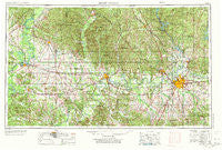
~ Montgomery AL topo map, 1:250000 scale, 1 X 2 Degree, Historical, 1953, updated 1973
Montgomery, Alabama, USGS topographic map dated 1953.
Includes geographic coordinates (latitude and longitude). This topographic map is suitable for hiking, camping, and exploring, or framing it as a wall map.
Printed on-demand using high resolution imagery, on heavy weight and acid free paper, or alternatively on a variety of synthetic materials.
Topos available on paper, Waterproof, Poly, or Tyvek. Usually shipping rolled, unless combined with other folded maps in one order.
- Product Number: USGS-5542911
- Free digital map download (high-resolution, GeoPDF): Montgomery, Alabama (file size: 23 MB)
- Map Size: please refer to the dimensions of the GeoPDF map above
- Weight (paper map): ca. 55 grams
- Map Type: POD USGS Topographic Map
- Map Series: HTMC
- Map Verison: Historical
- Cell ID: 68918
- Scan ID: 305929
- Imprint Year: 1973
- Woodland Tint: Yes
- Aerial Photo Year: 1952
- Edit Year: 1969
- Field Check Year: 1953
- Datum: Unstated
- Map Projection: Transverse Mercator
- Map published by United States Geological Survey
- Map published by: Military, Other
- Map Language: English
- Scanner Resolution: 600 dpi
- Map Cell Name: Montgomery
- Grid size: 1 X 2 Degree
- Date on map: 1953
- Map Scale: 1:250000
- Geographical region: Alabama, United States
Neighboring Maps:
All neighboring USGS topo maps are available for sale online at a variety of scales.
Spatial coverage:
Topo map Montgomery, Alabama, covers the geographical area associated the following places:
- Hillwood West - Kid - Wedgeworth - Crewsville - Pike Road - Curbville - Millwood - Spur (historical) - Independence - Rolling Lakes - Vineland - Demopolis - Roxana - Gunter Grove - New Town - Dixie - Forest Hills - Abercrombie - McGehees - Eutaw - Young Forte Village - Isabella - Brentwood - Dayton - Wetumpka - Newbern - Falkner - Freetown - Catoma - Sunshine - Melmar - Stanton - Ironville - Gay Meadows - Havana - Hillside (historical) - Morningview - Union - Redland Bluffs - Ingram - Speed - Ackerville - Fostoria - Onoqua (historical) - Cedarville - Macedonia - Hayneville - Snow Hill - Old Kingston - Valley Creek Junction - Wadsworth - Bellemeade - Booth - Mount Meigs Station - Safford - Claud - Clanton - Peace - Macedonia - Rollins - Westgate - Mount Sinai - Billingsley - Duff Settlement - Powelldale - Willowbrook - Fairview - Wilder Hill (historical) - Donald - Five Points - College Grove - Paces (historical) - Pine Needles - Coosada - Regency Park - Hill Top - Grovewood - Whispering Pines - Oak Grove - Brassell Bottom - Braggville - Centreville - Heiberger - Village West - Mobile Heights - Maud - Pintlala - Prairie View Estates - Gap of the Mountain - Plantersville - Arrowhead - Boylston - Red Level - Sweet Water - Anne Manie - Washington (historical) - Pondville - Zimmerman - Ridgefield - Shepherd Hill
- Map Area ID: AREA3332-88-86
- Northwest corner Lat/Long code: USGSNW33-88
- Northeast corner Lat/Long code: USGSNE33-86
- Southwest corner Lat/Long code: USGSSW32-88
- Southeast corner Lat/Long code: USGSSE32-86
- Northern map edge Latitude: 33
- Southern map edge Latitude: 32
- Western map edge Longitude: -88
- Eastern map edge Longitude: -86


