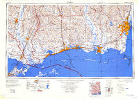
~ Mobile AL topo map, 1:250000 scale, 1 X 2 Degree, Historical, 1984, updated 1984
Mobile, Alabama, USGS topographic map dated 1984.
Includes geographic coordinates (latitude and longitude). This topographic map is suitable for hiking, camping, and exploring, or framing it as a wall map.
Printed on-demand using high resolution imagery, on heavy weight and acid free paper, or alternatively on a variety of synthetic materials.
Topos available on paper, Waterproof, Poly, or Tyvek. Usually shipping rolled, unless combined with other folded maps in one order.
- Product Number: USGS-5542901
- Free digital map download (high-resolution, GeoPDF): Mobile, Alabama (file size: 17 MB)
- Map Size: please refer to the dimensions of the GeoPDF map above
- Weight (paper map): ca. 55 grams
- Map Type: POD USGS Topographic Map
- Map Series: HTMC
- Map Verison: Historical
- Cell ID: 68917
- Scan ID: 707480
- Imprint Year: 1984
- Aerial Photo Year: 1952
- Edit Year: 1970
- Datum: Unstated
- Map Projection: Transverse Mercator
- Map published by United States Army Corps of Engineers
- Map Language: English
- Scanner Resolution: 508 dpi
- Map Cell Name: Mobile
- Grid size: 1 X 2 Degree
- Date on map: 1984
- Map Scale: 1:250000
- Geographical region: Alabama, United States
Neighboring Maps:
All neighboring USGS topo maps are available for sale online at a variety of scales.
Spatial coverage:
Topo map Mobile, Alabama, covers the geographical area associated the following places:
- Barry Village - Dale - Hidden River Mobile Ranch - Scenic Hills - Wilmer - White Harbor - Brugier - Sherwood Village Mobile Home Park - Juniper Grove - Semmes - Wool Market Mobile Home Park - North Gulfport - Country Mobile Home Park - Ford - Parc D'Orleans Number 2 Mobile Home Park - Theodore Mobile Home Park - Rolling Acres - Crossroads - Grand Bay - Isabell (historical) - East Pascagoula - Pecan Ridge Mobile Home Park - Prichard - Fords Creek - Spanish Trail Highlands - Anchor Trailer Park - Town Mobile Home Park - Celeste - Oakmont - Tabor Trailer Park - Georgetown - Pala Verdes Mobile Home Park - Bayou Vincent - Chamale Cove - Fruitland Park - Dees - Bennett (historical) - Eau Claire Estates - Grasslawn Mobile Home Park - Orvisburg - Dawes - McCall Landing - Barrington Park - Smithtown - Howells Ferry Heights - Waveland - Cochran Place Mobile Home Park - Popetown - Slidell Ozone Heights - Crichton - Big Branch - Skyland Park Estates - Oak Ridge - Castle Manor - Sawmill Pointe - Rivercrest - De La Be Forrest Mobile Home Park - Sun - Nix Mobile Home Park - Vaughan - Mill Creek - Lizana - Lindberg Glen - Parkview Estates - Cedar Lake - Alexis Place Trailer Park - Boothetown - Holly Landing - Perkinston - Sunny Cove - Gainesville - Eubanks (historical) - Kiln - Carriage Hills - Whisper Oaks Trailer Park - India - Ozona - Oak Manor Estates - Santa Rosa - Helena - Mauvilla Forest Estates - Log Cabin Trailer Court - Summit Mobile Home Park - Green Park West Mobile Home Park - Bryson Acres Trailer Park - Timberland Trailer Park - Jackson Heights - Wards Mobile Home Park - Laws Landing Trailer Park - Shady Oak Mobile Park - Landon - Logtown - Bell Terre Acres - Saint Elmo - Coden - Epico (historical) - Ocean Springs - Griffith Mobile Home Park - Whistler - North Biloxi
- Map Area ID: AREA3130-90-88
- Northwest corner Lat/Long code: USGSNW31-90
- Northeast corner Lat/Long code: USGSNE31-88
- Southwest corner Lat/Long code: USGSSW30-90
- Southeast corner Lat/Long code: USGSSE30-88
- Northern map edge Latitude: 31
- Southern map edge Latitude: 30
- Western map edge Longitude: -90
- Eastern map edge Longitude: -88

