
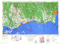
~ Mobile AL topo map, 1:250000 scale, 1 X 2 Degree, Historical, 1984, updated 1984
Mobile, Alabama, USGS topographic map dated 1984.
Includes geographic coordinates (latitude and longitude). This topographic map is suitable for hiking, camping, and exploring, or framing it as a wall map.
Printed on-demand using high resolution imagery, on heavy weight and acid free paper, or alternatively on a variety of synthetic materials.
Topos available on paper, Waterproof, Poly, or Tyvek. Usually shipping rolled, unless combined with other folded maps in one order.
- Product Number: USGS-5542899
- Free digital map download (high-resolution, GeoPDF): Mobile, Alabama (file size: 19 MB)
- Map Size: please refer to the dimensions of the GeoPDF map above
- Weight (paper map): ca. 55 grams
- Map Type: POD USGS Topographic Map
- Map Series: HTMC
- Map Verison: Historical
- Cell ID: 68917
- Scan ID: 707478
- Imprint Year: 1984
- Woodland Tint: Yes
- Aerial Photo Year: 1952
- Field Check Year: 1953
- Datum: Unstated
- Map Projection: Transverse Mercator
- Map published by United States Army Corps of Engineers
- Map Language: English
- Scanner Resolution: 508 dpi
- Map Cell Name: Mobile
- Grid size: 1 X 2 Degree
- Date on map: 1984
- Map Scale: 1:250000
- Geographical region: Alabama, United States
Neighboring Maps:
All neighboring USGS topo maps are available for sale online at a variety of scales.
Spatial coverage:
Topo map Mobile, Alabama, covers the geographical area associated the following places:
- Rivercrest - Mitch (historical) - Airey - Lake Gardens - Sherwood - Kali-Oka Springs - Gunn Place Trailer Park - Dedeaux - Woodlawn Acres - Northshore Mobile Home Park - Eagle Lake Mobile Home Park - Henderson Point - Carriere - Hidden Acres Mobile Home Park - Salmen - Dream Courts Mobile Home Park - Oak Grove Estates - Poolside Mobile Home Village - North Gulfport - Angie - Bay Saint Louis - Slidell Ozone Heights - Westchester Estates - Woodridge Estates Mobile Home Park - Pennsylvania - Hilda - Pearlington - Pine Crest Mobile Home Park - Country Club Mobile Home Park - Silver Creek Acres - Saucier - Smith Town - Oakway Trailer Park - Cadillac Park - Shepherds Mobile Home Park - Porters River Landing - Bayou La Batre - Old Government Mobile Home Park - Hillview Trailer Park - Cochran Place Mobile Home Park - Dees Landing - Mobile - East Pascagoula - Junior Acres - Pearl River - Fords Creek - Messer's Mobile Manor - Helena - Chunchula - Saint Joe - Rigolets - Windsor Place - Shady Grove Mobile Home Park - Slidell Manor - Cottage Park Estates - Deer Mobile Park - Kathy Mobile Park - Logtown - Magnolia Heights - Chesterfield Estates - Browns Village - Barrington Park - Cates Mobile Home Park - Gulf Park Estates - Florenville - Pettis Mobile Park - Todd Acres - Theodore Mobile Home Park - Couves Mobile Home Park - Orange Grove - Harleston - Starlite Mobile Home Park - Marston (historical) - Allenville - Timber Lake Estates - Isle of Pines Mobile Home Village - Timber Ridge - Dolan's Mobile Home Park - Ponderosa - Bassenger Trailer Park - Tillmans Corner - Wimbledon Estates - Sunset Mobile Home Park - Edgewater Park - Red Top - Castle Manor - Evanston - Wool Market - Bayou Vista - Harmony Heights - Howison - Perkinston - Crawford Landing - Cottage Hill Estates - Prichard - Rolling Acres - Cedar Lake Mobile Home Village - Pine Oaks Mobile Home Park - Dees - Deep Creek
- Map Area ID: AREA3130-90-88
- Northwest corner Lat/Long code: USGSNW31-90
- Northeast corner Lat/Long code: USGSNE31-88
- Southwest corner Lat/Long code: USGSSW30-90
- Southeast corner Lat/Long code: USGSSE30-88
- Northern map edge Latitude: 31
- Southern map edge Latitude: 30
- Western map edge Longitude: -90
- Eastern map edge Longitude: -88


