
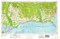
~ Mobile AL topo map, 1:250000 scale, 1 X 2 Degree, Historical, 1963, updated 1963
Mobile, Alabama, USGS topographic map dated 1963.
Includes geographic coordinates (latitude and longitude). This topographic map is suitable for hiking, camping, and exploring, or framing it as a wall map.
Printed on-demand using high resolution imagery, on heavy weight and acid free paper, or alternatively on a variety of synthetic materials.
Topos available on paper, Waterproof, Poly, or Tyvek. Usually shipping rolled, unless combined with other folded maps in one order.
- Product Number: USGS-5542893
- Free digital map download (high-resolution, GeoPDF): Mobile, Alabama (file size: 18 MB)
- Map Size: please refer to the dimensions of the GeoPDF map above
- Weight (paper map): ca. 55 grams
- Map Type: POD USGS Topographic Map
- Map Series: HTMC
- Map Verison: Historical
- Cell ID: 68917
- Scan ID: 305922
- Imprint Year: 1963
- Woodland Tint: Yes
- Edit Year: 1962
- Field Check Year: 1953
- Datum: Unstated
- Map Projection: Transverse Mercator
- Map published by United States Army Corps of Engineers
- Map published by United States Army
- Map Language: English
- Scanner Resolution: 600 dpi
- Map Cell Name: Mobile
- Grid size: 1 X 2 Degree
- Date on map: 1963
- Map Scale: 1:250000
- Geographical region: Alabama, United States
Neighboring Maps:
All neighboring USGS topo maps are available for sale online at a variety of scales.
Spatial coverage:
Topo map Mobile, Alabama, covers the geographical area associated the following places:
- Green Park West Mobile Home Park - Belvedere Estates - Yester Oaks - Mackies - Gulf Hills - Hyde Park - Magazine - Martin Bluff - Rivercrest - Semmes - Pine Grove - De La Be Forrest Mobile Home Park - Fernwood Trailer Court - Timber Ridge - Spanish Oaks Trail Mobile Home Park - CNA Estates Mobile Home Park - Hidden Acres Mobile Home Park - Little Pines - Ocean Springs - Browns Mobile Park - Imperial Mobile Estates - Bush - Irvings (historical) - Irene Hoffman Trailer Park - Adams Mobile Home Park - Beauvoir - Whistler - Century Oaks Retirement Community Mobile Home Park - Foxhollow - Morgan Bluff - Idlewood - Meadow Lane Estates - White Kitchen - Axis - Log Cabin Trailer Court - North Shore Beach - Warley - Woodland Park Mobile Home Village - Carriage Hills - De Buys - Tacon - Norwood - Mauvilla - Wool Market - Whisperwood Estates - Varnado - Navco - Palestine - Christi Ann Lea - Perry - Stevensons Trailer Court - Grand Bay - Colt - Barnes Road Trailer Park - Bulah - Forest Highlands - Oakleigh Estates - Bayside Park - Bayleys Corner - Crawford - Forest Glen (historical) - Village de L'Est - Bellamy (historical) - Mill Creek - Winthrop Square - Fort Bayou Estates - Country Club Village - Hawthorne - Maude - Abney Estates - Alexis Place Trailer Park - McNeill - Salco - Park Forest - Wilmer - Angie - Shelton Beach Estates - Saint Elmo - Smallwood Mobile Home Park - Hillsdale - Homestead Mobile Home Park - Sunny Cove - Huntwyck Village - Ford - East Gentilly - Lake Shore Village - Princeton Woods - Whisper Oaks Trailer Park - Lakeshore - Diamondhead - Pala Verdes Mobile Home Park - Slaughter Flat Landing - Creola Mobile Home Park - Grand Oaks Mobile Home Court - Audubon Place Plaza - Skyland Park Estates - Omas Pine Mobile Home Park - Crane Creek - Coll Town - Belle Chene
- Map Area ID: AREA3130-90-88
- Northwest corner Lat/Long code: USGSNW31-90
- Northeast corner Lat/Long code: USGSNE31-88
- Southwest corner Lat/Long code: USGSSW30-90
- Southeast corner Lat/Long code: USGSSE30-88
- Northern map edge Latitude: 31
- Southern map edge Latitude: 30
- Western map edge Longitude: -90
- Eastern map edge Longitude: -88


