
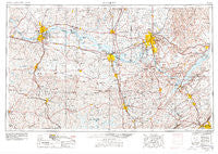
~ Gadsden AL topo map, 1:250000 scale, 1 X 2 Degree, Historical, 1956, updated 1978
Gadsden, Alabama, USGS topographic map dated 1956.
Includes geographic coordinates (latitude and longitude). This topographic map is suitable for hiking, camping, and exploring, or framing it as a wall map.
Printed on-demand using high resolution imagery, on heavy weight and acid free paper, or alternatively on a variety of synthetic materials.
Topos available on paper, Waterproof, Poly, or Tyvek. Usually shipping rolled, unless combined with other folded maps in one order.
- Product Number: USGS-5542887
- Free digital map download (high-resolution, GeoPDF): Gadsden, Alabama (file size: 23 MB)
- Map Size: please refer to the dimensions of the GeoPDF map above
- Weight (paper map): ca. 55 grams
- Map Type: POD USGS Topographic Map
- Map Series: HTMC
- Map Verison: Historical
- Cell ID: 68793
- Scan ID: 305919
- Imprint Year: 1978
- Aerial Photo Year: 1976
- Edit Year: 1977
- Field Check Year: 1956
- Datum: Unstated
- Map Projection: Transverse Mercator
- Map published by: Military, Other
- Map Language: English
- Scanner Resolution: 600 dpi
- Map Cell Name: Gadsden
- Grid size: 1 X 2 Degree
- Date on map: 1956
- Map Scale: 1:250000
- Geographical region: Alabama, United States
Neighboring Maps:
All neighboring USGS topo maps are available for sale online at a variety of scales.
Spatial coverage:
Topo map Gadsden, Alabama, covers the geographical area associated the following places:
- Thirtynine (historical) - Claysville - Manchester - Avery - Valley Grove - Mecca (historical) - Union - Tanglewood - Bartlett (historical) - Churntown - Susan Moore - Batts Nest (historical) - Rose Park - Landersville - Helicon - Dogwood - Lakeview - Southern (historical) - Sherill Gardens - Carroll Crossroads - Masonville (historical) - Georgia - Mountainboro - Hillandale - Oak Grove - Oakdale Acres - Point of Pines Subdivision - Elon - Creekwood - Lumbull - Redbud - Sweetwater - Confluence - Morris Crossroads - Thach - Mount Hope - Underwood Heights - Carey - Neel - Hulaco - Hawk Pride - New Bethel - Ferns Quarter (historical) - Agricola - Rollins (historical) - Old Monrovia - Hickory Hills - Sherwood Estates - Little New York - Village Number 1 - Canaan (historical) - Bethel (historical) - Copeland Gap - Hines - Reedtown - Natural Bridge - Shoals Acres - Irvington - Hub (historical) - Fridays Crossing - Meadow Trace - Detroit Park - Union Grove - Lawngate - Evergreen Estates - Cottonville - Steppville - Brooksville - Ruth - Woodlawn - Poplar Creek (historical) - Princeton - Flatwoods - Pane (historical) - Pride - Mount Carmel - Longview - Dallas - May Apple (historical) - Poplar Springs - Green Hills - Aspel - Union - Good Springs - Gravel Hill - Wren - Rhea (historical) - Batts Heights - Lakewood Manor - Brooks Acres - Rivermont - New Georgia (historical) - Scoggins Bottoms (historical) - Aqua Vista - Union Hill - Carlisle - Alabama City - Crane Hill - Olland - Vaughn Corners
- Map Area ID: AREA3534-88-86
- Northwest corner Lat/Long code: USGSNW35-88
- Northeast corner Lat/Long code: USGSNE35-86
- Southwest corner Lat/Long code: USGSSW34-88
- Southeast corner Lat/Long code: USGSSE34-86
- Northern map edge Latitude: 35
- Southern map edge Latitude: 34
- Western map edge Longitude: -88
- Eastern map edge Longitude: -86


