
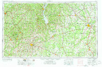
~ Dothan AL topo map, 1:250000 scale, 1 X 2 Degree, Historical, 1953, updated 1977
Dothan, Alabama, USGS topographic map dated 1953.
Includes geographic coordinates (latitude and longitude). This topographic map is suitable for hiking, camping, and exploring, or framing it as a wall map.
Printed on-demand using high resolution imagery, on heavy weight and acid free paper, or alternatively on a variety of synthetic materials.
Topos available on paper, Waterproof, Poly, or Tyvek. Usually shipping rolled, unless combined with other folded maps in one order.
- Product Number: USGS-5542873
- Free digital map download (high-resolution, GeoPDF): Dothan, Alabama (file size: 21 MB)
- Map Size: please refer to the dimensions of the GeoPDF map above
- Weight (paper map): ca. 55 grams
- Map Type: POD USGS Topographic Map
- Map Series: HTMC
- Map Verison: Historical
- Cell ID: 68752
- Scan ID: 305912
- Imprint Year: 1977
- Woodland Tint: Yes
- Edit Year: 1965
- Field Check Year: 1953
- Datum: Unstated
- Map Projection: Transverse Mercator
- Map published by United States Army Corps of Engineers
- Map published by United States Army
- Map Language: English
- Scanner Resolution: 600 dpi
- Map Cell Name: Dothan
- Grid size: 1 X 2 Degree
- Date on map: 1953
- Map Scale: 1:250000
- Geographical region: Alabama, United States
Neighboring Maps:
All neighboring USGS topo maps are available for sale online at a variety of scales.
Spatial coverage:
Topo map Dothan, Alabama, covers the geographical area associated the following places:
- Bertha - Pine Lake Estates - Eunola - Fairfield Estates - Jeff - New Brockton - Armena - Barefield Crossroads - Avon - Black Gum Corners (historical) - Thurston - Kirklands Crossroads - Forest Park - Kalmon - Cedar Heights - Springfield - Westgate - Woodland Hills - Hayes - Shackleford Place - Northside - Scottsboro Crossroads - Ozark - Nutview (historical) - Abbeville - Shellman - Georgetown - Miriam Heights - North Heights - Mountainbrook - Lamar - Solomon Heights - Headland - Clopton - Rowena - Southside Acres - Vanlandingham Mill - Silver Meadows - Wilson Trailer Park - Garmon Crossroads - Love Hill - Doster - Foxhill - Maddox - Sandalwood - Rio Vista - Doverel - Doublegate - Airport Subdivision - Pine Ridge Estates - Olivers Lake - Sherwood Forest - Hobdy - Avert Acres - Grubb (historical) - Hodgesville - Sandy Point - Martins Crossroads - Jones Crossing - Hoggard Mill - Hollywood - Cayman Bay Mobile Home Park - Chateau Estates - Omega - Kelly - Dykes Crossroad - Hentown - Smyrna - Fields (historical) - Clayhatchee - Flint - Alaga - Akinsville - Richland - Bowden Terrace - Spann Brothers Estates - Holt - Greenwood - Tarentum - Scrutchins - Oakville - Worner (historical) - Clio - Mossy Grove - Oketeyeconne (historical) - Baker Hill - Bluffton - Tennille - Parkers (historical) - Terese - Town and Country Estates - Cedar Springs - Laurel Grove (historical) - Starksville - Deerfield Park - Pickett - Little Hope - Screamer - Lockett Crossing - Florary
- Map Area ID: AREA3231-86-84
- Northwest corner Lat/Long code: USGSNW32-86
- Northeast corner Lat/Long code: USGSNE32-84
- Southwest corner Lat/Long code: USGSSW31-86
- Southeast corner Lat/Long code: USGSSE31-84
- Northern map edge Latitude: 32
- Southern map edge Latitude: 31
- Western map edge Longitude: -86
- Eastern map edge Longitude: -84


