
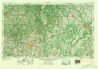
~ Dothan AL topo map, 1:250000 scale, 1 X 2 Degree, Historical, 1955, updated 1955
Dothan, Alabama, USGS topographic map dated 1955.
Includes geographic coordinates (latitude and longitude). This topographic map is suitable for hiking, camping, and exploring, or framing it as a wall map.
Printed on-demand using high resolution imagery, on heavy weight and acid free paper, or alternatively on a variety of synthetic materials.
Topos available on paper, Waterproof, Poly, or Tyvek. Usually shipping rolled, unless combined with other folded maps in one order.
- Product Number: USGS-5542871
- Free digital map download (high-resolution, GeoPDF): Dothan, Alabama (file size: 27 MB)
- Map Size: please refer to the dimensions of the GeoPDF map above
- Weight (paper map): ca. 55 grams
- Map Type: POD USGS Topographic Map
- Map Series: HTMC
- Map Verison: Historical
- Cell ID: 68752
- Scan ID: 305911
- Imprint Year: 1955
- Woodland Tint: Yes
- Field Check Year: 1953
- Datum: Unstated
- Map Projection: Transverse Mercator
- Map published by United States Army Corps of Engineers
- Map published by United States Army
- Map Language: English
- Scanner Resolution: 600 dpi
- Map Cell Name: Dothan
- Grid size: 1 X 2 Degree
- Date on map: 1955
- Map Scale: 1:250000
- Geographical region: Alabama, United States
Neighboring Maps:
All neighboring USGS topo maps are available for sale online at a variety of scales.
Spatial coverage:
Topo map Dothan, Alabama, covers the geographical area associated the following places:
- Pleasant Hill - Omega - Country Club Meadows - Logton - Tanyard - Brown Estates - Rehobeth - Keyton - Garmon Crossroads - Edgefield - Tumbleton - Chancellor - Oak Ridge - Patmos - Lamar - Avon - Windmill Hills - Hartford - Vanlandingham Mill - Briarhill Acres - Aycock Mill - Folks (historical) - Shackleford Place - Whitaker (historical) - Philema - Highland Park - Byne Crossroads - Bertha - Rock Creek Park - Pleasant Plains - Chambliss - Lugo - Pansey - Paradise Village Mobile Home Park - Oakdale - Sullivan Heights - Stills Crossroads - Hebron - Rawson Park - Highland Park - Deerfield Park - Graball - Cotton Hill - Urquhart - Sharphagen - Stroms - Gerald - Cottondale - Parksville - Central City - Hentown - Eugemar - Petty (historical) - Powell Place - Town and Country Estates - Stocks (historical) - Bellville - Colonial Place - Westview - Dixieland - Pine Forest - Vann - Otho - Vancise - Valley Park - Chokee - Country Estates - Solomon Heights - Hobdy - Whispering Pines - Blue Springs - Century - Worner (historical) - Union - White Oak - Sumter - Spears - Rainbow Mobile Home Park - College Park - Town and Country Acres - Centerpoint - Avalon - Sanford - Balkum - Pinewood Estates - Iron City - Tabernacle - Leesburg - Harrisons Mill - Palms Mobile Home Park - Iveys Mill - North Ridge Mobile Home Park - Nicholasville - Lowry Mill - Chateau Court - Monticello - Victoria - Damascus - Melody Heights - Peach Tree Hills
- Map Area ID: AREA3231-86-84
- Northwest corner Lat/Long code: USGSNW32-86
- Northeast corner Lat/Long code: USGSNE32-84
- Southwest corner Lat/Long code: USGSSW31-86
- Southeast corner Lat/Long code: USGSSE31-84
- Northern map edge Latitude: 32
- Southern map edge Latitude: 31
- Western map edge Longitude: -86
- Eastern map edge Longitude: -84


