
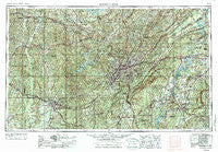
~ Birmingham AL topo map, 1:250000 scale, 1 X 2 Degree, Historical, 1953, updated 1976
Birmingham, Alabama, USGS topographic map dated 1953.
Includes geographic coordinates (latitude and longitude). This topographic map is suitable for hiking, camping, and exploring, or framing it as a wall map.
Printed on-demand using high resolution imagery, on heavy weight and acid free paper, or alternatively on a variety of synthetic materials.
Topos available on paper, Waterproof, Poly, or Tyvek. Usually shipping rolled, unless combined with other folded maps in one order.
- Product Number: USGS-5542869
- Free digital map download (high-resolution, GeoPDF): Birmingham, Alabama (file size: 25 MB)
- Map Size: please refer to the dimensions of the GeoPDF map above
- Weight (paper map): ca. 55 grams
- Map Type: POD USGS Topographic Map
- Map Series: HTMC
- Map Verison: Historical
- Cell ID: 68677
- Scan ID: 305910
- Imprint Year: 1976
- Woodland Tint: Yes
- Visual Version Number: 2
- Aerial Photo Year: 1952
- Edit Year: 1969
- Field Check Year: 1953
- Datum: Unstated
- Map Projection: Transverse Mercator
- Map published by United States Geological Survey
- Map published by: Military, Other
- Map Language: English
- Scanner Resolution: 600 dpi
- Map Cell Name: Birmingham
- Grid size: 1 X 2 Degree
- Date on map: 1953
- Map Scale: 1:250000
- Geographical region: Alabama, United States
Neighboring Maps:
All neighboring USGS topo maps are available for sale online at a variety of scales.
Spatial coverage:
Topo map Birmingham, Alabama, covers the geographical area associated the following places:
- Burmah (historical) - Hazelhurst - Taylorville Heights - Southpointe - Fairfield - Rocky Ridge - Shelby - Patton Chapel - Overbrook Estates - Woodcrest - Queenstown - Smith Acres - Cooks Springs - Union Chapel - Five Points East - Shadywood - Grimes - Lexington Downs - Simpson Subdivision - Balle Mobile Home Park - Irondale - Bessemer Homestead - Wheeling Crossroad - Tuxedo Heights - High Point - Harkness Crossroads - Wisteria Commons - Central Highlands - Williamsburg - Brents Cross Roads - Madison - Crestmont - Holt - Riveria Estates - Kowakas Mobile Home Park - Siberton - Appalachian - Falls Junction - Green Acres - Oak Ridge - Nash (historical) - Colonial Hills - Adger - Hickory Ridge Estates - Lester - Simmsville - Westhill - Mission Hills - Tanyard - Gu-Win - Eastwood Villa - Fairview - Pine Crest - Lake Cove - Hillcrest Estates - Avalon Park - Old Mill Trace - Tangle Creek - Ruffner - Royal Pines - Bethel - Center Point Gardens - Hillman Park - Dolomite - Straven - Robinwood - Parkwood - Fairlawn - Sixmile - Windham Springs - Northwood Forest - Four Winds - Homestead - Brook Highland - Doliska - Hickory Ridge Estates - Mountain Oaks - Liberty Highlands - Valley View - Eastbrook Manor - Lakeview Manor - Lakeview Estates - North Riviera - Weller - Springdale - Renfroe - Falliston - Brookwood - Buena Vista - Pleasant Grove - Dora Junction - Easley - Corona - Hays Court - Altadena Woods - Hoagtown - Banks - Lovick - Chestnut Glen - Old Jonesboro
- Map Area ID: AREA3433-88-86
- Northwest corner Lat/Long code: USGSNW34-88
- Northeast corner Lat/Long code: USGSNE34-86
- Southwest corner Lat/Long code: USGSSW33-88
- Southeast corner Lat/Long code: USGSSE33-86
- Northern map edge Latitude: 34
- Southern map edge Latitude: 33
- Western map edge Longitude: -88
- Eastern map edge Longitude: -86


