
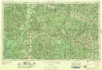
~ Andalusia AL topo map, 1:250000 scale, 1 X 2 Degree, Historical, 1957, updated 1957
Andalusia, Alabama, USGS topographic map dated 1957.
Includes geographic coordinates (latitude and longitude). This topographic map is suitable for hiking, camping, and exploring, or framing it as a wall map.
Printed on-demand using high resolution imagery, on heavy weight and acid free paper, or alternatively on a variety of synthetic materials.
Topos available on paper, Waterproof, Poly, or Tyvek. Usually shipping rolled, unless combined with other folded maps in one order.
- Product Number: USGS-5542853
- Free digital map download (high-resolution, GeoPDF): Andalusia, Alabama (file size: 27 MB)
- Map Size: please refer to the dimensions of the GeoPDF map above
- Weight (paper map): ca. 55 grams
- Map Type: POD USGS Topographic Map
- Map Series: HTMC
- Map Verison: Historical
- Cell ID: 68647
- Scan ID: 305902
- Imprint Year: 1957
- Woodland Tint: Yes
- Aerial Photo Year: 1952
- Field Check Year: 1953
- Datum: Unstated
- Map Projection: Transverse Mercator
- Map published by United States Army Corps of Engineers
- Map published by United States Army
- Map Language: English
- Scanner Resolution: 600 dpi
- Map Cell Name: Andalusia
- Grid size: 1 X 2 Degree
- Date on map: 1957
- Map Scale: 1:250000
- Geographical region: Alabama, United States
Neighboring Maps:
All neighboring USGS topo maps are available for sale online at a variety of scales.
Spatial coverage:
Topo map Andalusia, Alabama, covers the geographical area associated the following places:
- Stokes - Renson - Hotamville - Dickinson - Pleasant Hill - Raley Forest Hill - Straughn - Social Town - Beacon - Flatwoods - Caledonia - Zoar - Dixie - Watsonville - Petrey - Falco - Helicon - Mulberry - Loango - Choctaw Bluff - Rock Hill - Sand Cut - Palmyra - Axle - Darlington - Winn - Tallahatta Springs - Vashti - Bluff Springs - Friendship - Fountain - Green Bay - Valley of Shiloh - Commerce - Fort Deposit - Pineville - Hestle - Georgiaville - Marietta - Manila - Grove Hill - Spring Hill - Hamburg - Franklin - Clearview - Pine Hill - Mixonville - Industry - Estelle - Perry Store - Peacock - Rhodes - Theba - Leroy - Providence - Stanley Crossroads - Chrysler - Monroeton - Vaughn - Cherokee Village - Palmers Crossroads - Wainwright - Awin - Cooks Crossroads - Sardis - Rural - Centerville - Deans - Rock Springs - Duvall - Curry - Rabb - Allred - Allenton - East Chapman - Latham - Hammac - McCullough - Macedonia - Redtown - Pollard - Nokomis - Lakewood Mobile Home Park - McWer - Pine Level - Reddock Springs - Ivy Creek - Rhump - Kent - Henderson - Mexia Crossing - Keego - Whatley - Excel - Keith - Lee - Beda - Robinson Crossroads - Old Town - Friendship
- Map Area ID: AREA3231-88-86
- Northwest corner Lat/Long code: USGSNW32-88
- Northeast corner Lat/Long code: USGSNE32-86
- Southwest corner Lat/Long code: USGSSW31-88
- Southeast corner Lat/Long code: USGSSE31-86
- Northern map edge Latitude: 32
- Southern map edge Latitude: 31
- Western map edge Longitude: -88
- Eastern map edge Longitude: -86


