
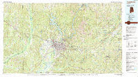
~ Tuscaloosa AL topo map, 1:100000 scale, 30 X 60 Minute, Historical, 1984, updated 1988
Tuscaloosa, Alabama, USGS topographic map dated 1984.
Includes geographic coordinates (latitude and longitude). This topographic map is suitable for hiking, camping, and exploring, or framing it as a wall map.
Printed on-demand using high resolution imagery, on heavy weight and acid free paper, or alternatively on a variety of synthetic materials.
Topos available on paper, Waterproof, Poly, or Tyvek. Usually shipping rolled, unless combined with other folded maps in one order.
- Product Number: USGS-5542641
- Free digital map download (high-resolution, GeoPDF): Tuscaloosa, Alabama (file size: 32 MB)
- Map Size: please refer to the dimensions of the GeoPDF map above
- Weight (paper map): ca. 55 grams
- Map Type: POD USGS Topographic Map
- Map Series: HTMC
- Map Verison: Historical
- Cell ID: 68495
- Scan ID: 305782
- Imprint Year: 1988
- Woodland Tint: Yes
- Aerial Photo Year: 1981
- Edit Year: 1984
- Datum: NAD27
- Map Projection: Universal Transverse Mercator
- Map published by United States Geological Survey
- Map Language: English
- Scanner Resolution: 600 dpi
- Map Cell Name: Tuscaloosa
- Grid size: 30 X 60 Minute
- Date on map: 1984
- Map Scale: 1:100000
- Geographical region: Alabama, United States
Neighboring Maps:
All neighboring USGS topo maps are available for sale online at a variety of scales.
Spatial coverage:
Topo map Tuscaloosa, Alabama, covers the geographical area associated the following places:
- Coleanor - High Cliff - Brookside - Smith Acres - Timberlane - Royal Pines - Rivermont - Arlington Drive - Westhill - Coaling - Virginia - Riverside Circle - Lake Shore - Box Springs - Monticello Estates - Nash Town (historical) - Gray Hill - Shirley - Colonial Hills - Alpine Hills - Westview - Forest Hills - Tannehill - Twin Manor - Berkshire Estates - East Lake - Chewalla - The Highlands - Stonehedge Cliffs - Brentwood - Hillsdale - Sahama Village - Kennedy Park - Riverwood - Meadow Lawn - Cottonwood Park - North Bibb - Cedar Knoll - Sommerville - Lavelle Woods - Taylorville - Sartains Ridgecrest Subdivision - New Hargrove (historical) - Pinedale - Alta Vista - Oak Grove - Wood Village - Brookhaven - Dutton Place - Alberta City - Candlewood - Eastern Hills - Bellview Heights - Telmar Subdivision - Jena - Englewood - McCulley Creek - Cadillac Estates - Juanita Drive - Peach Grove - Cottondale - Terri Wood - Lake Front Village - Sycamore - Golden Acres - West Blocton - Asbury - Burmah (historical) - River Bend (historical) - Green Hills - University Manor - Moores Bridge - Valley View - Montgomery Lakes - Mantua - Smith Hill - Taylorwood Estates - Spring Brook - North Haven - East End - Oakdale - Coker - Fikestown (historical) - Red Eagle - Masena - Mount Olive - Sky Ranch - Fosters - Caffee Junction - North River Shores - Country Club Hills - Audubon Place - Ridgeland - Crestmont - Norris Circle - Crestwood - Cherry Dale - Lake Hills North - Lincoln Park - Laurel Hills
- Map Area ID: AREA33.533-88-87
- Northwest corner Lat/Long code: USGSNW33.5-88
- Northeast corner Lat/Long code: USGSNE33.5-87
- Southwest corner Lat/Long code: USGSSW33-88
- Southeast corner Lat/Long code: USGSSE33-87
- Northern map edge Latitude: 33.5
- Southern map edge Latitude: 33
- Western map edge Longitude: -88
- Eastern map edge Longitude: -87


