
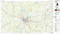
~ Tuscaloosa AL topo map, 1:100000 scale, 30 X 60 Minute, Historical, 1984, updated 1985
Tuscaloosa, Alabama, USGS topographic map dated 1984.
Includes geographic coordinates (latitude and longitude). This topographic map is suitable for hiking, camping, and exploring, or framing it as a wall map.
Printed on-demand using high resolution imagery, on heavy weight and acid free paper, or alternatively on a variety of synthetic materials.
Topos available on paper, Waterproof, Poly, or Tyvek. Usually shipping rolled, unless combined with other folded maps in one order.
- Product Number: USGS-5542639
- Free digital map download (high-resolution, GeoPDF): Tuscaloosa, Alabama (file size: 20 MB)
- Map Size: please refer to the dimensions of the GeoPDF map above
- Weight (paper map): ca. 55 grams
- Map Type: POD USGS Topographic Map
- Map Series: HTMC
- Map Verison: Historical
- Cell ID: 68495
- Scan ID: 305781
- Imprint Year: 1985
- Woodland Tint: Yes
- Aerial Photo Year: 1981
- Edit Year: 1984
- Datum: NAD27
- Map Projection: Universal Transverse Mercator
- Planimetric: Yes
- Map published by United States Geological Survey
- Map Language: English
- Scanner Resolution: 600 dpi
- Map Cell Name: Tuscaloosa
- Grid size: 30 X 60 Minute
- Date on map: 1984
- Map Scale: 1:100000
- Geographical region: Alabama, United States
Neighboring Maps:
All neighboring USGS topo maps are available for sale online at a variety of scales.
Spatial coverage:
Topo map Tuscaloosa, Alabama, covers the geographical area associated the following places:
- Kicker Subdivision - Glenwood Park - Riverwood - Indian Lake - Searles - McCulley Creek - Ezra - Morrows Grove - Belle Ellen - Flat Top - East Lake - Mayfair - Bridgeview - Morayshire Estates - North Johns - River Bend (historical) - Pine Park - Arlington Mobile Home Park (historical) - Cumberland Park - Caffee Junction - Huntington Place - Oakdale - Brentwood - Cove Park - Crestmont - Westland - Shirley - Circlewood - Arlington Drive - Greenview - Norris Estates - Harper Subdivision - Ingleside Village - East End - West Circle - Bell - Ardela (historical) - Lake Hills North - Claymont - Bel Air Estates - Kennedy Park - Arnedra Subdivision - Parkside - Pioneer - Coleanor - Shawtown - Lexington Downs - East Circle - Hawkinsville (historical) - Gordo - Belchers - Whispering Hills - Hillsdale - Johns - Booth Estates - Briarwood - Woodland Hills - Monticello Estates - Standridge - Princeton Place - Lake View - North Valley Acres - The Glens - Oak Ridge - Brookside - Blue Creek - Coker Heights - Searcy Farms - Bellview Heights - West Haven - Forest Manor - Bar Wayne Circle - Highview - Alta Vista - Austin Subdivision - Smoke Rise - Cedar Knoll - Cresent Heights - Biscayne Hills - Heritage Hills - Taylorville Heights - Red Hill Heights - Hazelhurst - Rollingwood - High Cliff - Saratoga Estates - Westridge - Cherry Dale - Mariners Cove - Academy Park - Sixmile - El Dorado East - Lavelle Woods - Buena Vista - Asbury - Chestnut Hill - Deep Wood - Oak Grove - Peterson - Egypt (historical)
- Map Area ID: AREA33.533-88-87
- Northwest corner Lat/Long code: USGSNW33.5-88
- Northeast corner Lat/Long code: USGSNE33.5-87
- Southwest corner Lat/Long code: USGSSW33-88
- Southeast corner Lat/Long code: USGSSE33-87
- Northern map edge Latitude: 33.5
- Southern map edge Latitude: 33
- Western map edge Longitude: -88
- Eastern map edge Longitude: -87


