
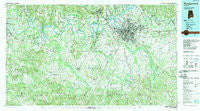
~ Montgomery AL topo map, 1:100000 scale, 30 X 60 Minute, Historical, 1986, updated 1989
Montgomery, Alabama, USGS topographic map dated 1986.
Includes geographic coordinates (latitude and longitude). This topographic map is suitable for hiking, camping, and exploring, or framing it as a wall map.
Printed on-demand using high resolution imagery, on heavy weight and acid free paper, or alternatively on a variety of synthetic materials.
Topos available on paper, Waterproof, Poly, or Tyvek. Usually shipping rolled, unless combined with other folded maps in one order.
- Product Number: USGS-5542631
- Free digital map download (high-resolution, GeoPDF): Montgomery, Alabama (file size: 32 MB)
- Map Size: please refer to the dimensions of the GeoPDF map above
- Weight (paper map): ca. 55 grams
- Map Type: POD USGS Topographic Map
- Map Series: HTMC
- Map Verison: Historical
- Cell ID: 67979
- Scan ID: 305777
- Imprint Year: 1989
- Woodland Tint: Yes
- Aerial Photo Year: 1984
- Edit Year: 1986
- Datum: NAD27
- Map Projection: Universal Transverse Mercator
- Map published by United States Geological Survey
- Map Language: English
- Scanner Resolution: 600 dpi
- Map Cell Name: Montgomery
- Grid size: 30 X 60 Minute
- Date on map: 1986
- Map Scale: 1:100000
- Geographical region: Alabama, United States
Neighboring Maps:
All neighboring USGS topo maps are available for sale online at a variety of scales.
Spatial coverage:
Topo map Montgomery, Alabama, covers the geographical area associated the following places:
- Whispering Pines - Gay Meadows - Mount Willing - Pine Brook Estates - Tyson - Willowbrook - Old Town - Cloverdale - Hunting Downs - Kingswood - Fairview - Pleasant Hill - Powelldale - Fleta - West End - North Pass - Tyler - Foxchase - Zion - Woodley Meadows - Mathews - Red Level - Collirene - Ada - Lowndesboro - Benton - Pintlala - Edgemont Heights - Park Manor - Carol Villa - Bellwood Plantation - Blue Ridge Estates - Executive Park - Woodland Hills - Heatherton Heights - Perrys Mill - Southmont - Prairie View Estates - Barachias - Rosemond Estates - Druid Hills - Gunter Grove - Grovewood - Southlawn East - North Montgomery - Kulumi (historical) - Washington Park - Garden Square - Melmar - Brentwood - Eastmont - New Bingham - Rosemary - Brantley - Swink - Cloverland - Brassell - Mayfair - English Village - Brickdale Estates - Mulberry - Onoqua (historical) - Upper Kingston - Sandy Ridge - Rosemont Heights - Edsons - Azalea Woods Estates - Lily Grove (historical) - Arrowhead - McGehee Estates - New Everdale - Montgomery East - Strata - Mitylene - Lagos del Sol - Great Oaks - Hobbie Farm - Dalraida - Farmersville - Canaan - Teasleys Mill - Autaugaville - Southlawn - Wareingwood - Burkville - Peace - Petronia - Young Forte Village - Roxana - Elsmeade - Morningview - Woodley Park - Robinson Crossroads - Currys - Cooks - Hillwood West - Highland Village - Halcyon - Regency Park - Woodcrest Estates
- Map Area ID: AREA32.532-87-86
- Northwest corner Lat/Long code: USGSNW32.5-87
- Northeast corner Lat/Long code: USGSNE32.5-86
- Southwest corner Lat/Long code: USGSSW32-87
- Southeast corner Lat/Long code: USGSSE32-86
- Northern map edge Latitude: 32.5
- Southern map edge Latitude: 32
- Western map edge Longitude: -87
- Eastern map edge Longitude: -86


