
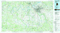
~ Montgomery AL topo map, 1:100000 scale, 30 X 60 Minute, Historical, 1986, updated 1986
Montgomery, Alabama, USGS topographic map dated 1986.
Includes geographic coordinates (latitude and longitude). This topographic map is suitable for hiking, camping, and exploring, or framing it as a wall map.
Printed on-demand using high resolution imagery, on heavy weight and acid free paper, or alternatively on a variety of synthetic materials.
Topos available on paper, Waterproof, Poly, or Tyvek. Usually shipping rolled, unless combined with other folded maps in one order.
- Product Number: USGS-5542629
- Free digital map download (high-resolution, GeoPDF): Montgomery, Alabama (file size: 24 MB)
- Map Size: please refer to the dimensions of the GeoPDF map above
- Weight (paper map): ca. 55 grams
- Map Type: POD USGS Topographic Map
- Map Series: HTMC
- Map Verison: Historical
- Cell ID: 67979
- Scan ID: 305776
- Imprint Year: 1986
- Woodland Tint: Yes
- Aerial Photo Year: 1984
- Edit Year: 1986
- Datum: NAD27
- Map Projection: Universal Transverse Mercator
- Planimetric: Yes
- Map published by United States Geological Survey
- Map Language: English
- Scanner Resolution: 600 dpi
- Map Cell Name: Montgomery
- Grid size: 30 X 60 Minute
- Date on map: 1986
- Map Scale: 1:100000
- Geographical region: Alabama, United States
Neighboring Maps:
All neighboring USGS topo maps are available for sale online at a variety of scales.
Spatial coverage:
Topo map Montgomery, Alabama, covers the geographical area associated the following places:
- Benton - Knollwood - New Everdale - Normandale - Governors Estates - Sunset Park Estates - Pine Acres - Mosswood - Westview Gardens - Spring Park - Hunting Ridge - Freeport - London - Country Estates - Prattmont - Brighton Estates - Lagos del Sol - John Lee Acres - Dublin - Mathews - Old Bingham - Olde Acres - Montgomery East - Open Acres - Lily Grove (historical) - Rolling Acres - Blue Ridge Estates - Gibson - Trickem - Sellers - Cloverdale - Hunter - Kulumi (historical) - Westgate - Pintlala - Autauga (historical) - New Town - Memorial Heights - Eastmont - Gunter Grove - Manack - Prairie View Estates - Fostoria - Dannley Pines - Kings - Powelldale - Hope Hull - Woodland Heights - Hobbie Farm - Windwood - Sunshine Village - Pine Level - Brantley - Regency Park - Azalea Woods Estates - Brickdale Estates - Georgetown - Park Manor - Hillcrest - Casey - Virginia Estates - Scenic Hills - Overlook - Naftel - Elsmeade - Hicks Hill - Manila - Brassell - Wareingwood - Meadville - Woodcrest Estates - Cantelous - Sandy Ridge - Grove Hill - Ranchette Estates - Clearview - Lum - McDade - Ramer - Autaugaville - Wadsworth - Bell Station - Bell Meadows - Catoma - Landmarks - Eastern Meadows - Young Forte Village - Mount Meigs Station - Minter - Calhoun - Robinson Crossroads - Cecil - Letohatchee - Rose Hill - Hayneville - College Grove - Old Vernon (historical) - Lakeview Heights - Barachias - Ware
- Map Area ID: AREA32.532-87-86
- Northwest corner Lat/Long code: USGSNW32.5-87
- Northeast corner Lat/Long code: USGSNE32.5-86
- Southwest corner Lat/Long code: USGSSW32-87
- Southeast corner Lat/Long code: USGSSE32-86
- Northern map edge Latitude: 32.5
- Southern map edge Latitude: 32
- Western map edge Longitude: -87
- Eastern map edge Longitude: -86


