
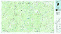
~ Monroeville AL topo map, 1:100000 scale, 30 X 60 Minute, Historical, 1986, updated 1986
Monroeville, Alabama, USGS topographic map dated 1986.
Includes geographic coordinates (latitude and longitude). This topographic map is suitable for hiking, camping, and exploring, or framing it as a wall map.
Printed on-demand using high resolution imagery, on heavy weight and acid free paper, or alternatively on a variety of synthetic materials.
Topos available on paper, Waterproof, Poly, or Tyvek. Usually shipping rolled, unless combined with other folded maps in one order.
- Product Number: USGS-5542625
- Free digital map download (high-resolution, GeoPDF): Monroeville, Alabama (file size: 21 MB)
- Map Size: please refer to the dimensions of the GeoPDF map above
- Weight (paper map): ca. 55 grams
- Map Type: POD USGS Topographic Map
- Map Series: HTMC
- Map Verison: Historical
- Cell ID: 67976
- Scan ID: 305774
- Imprint Year: 1986
- Woodland Tint: Yes
- Aerial Photo Year: 1984
- Edit Year: 1986
- Datum: NAD27
- Map Projection: Universal Transverse Mercator
- Planimetric: Yes
- Map published by United States Geological Survey
- Map Language: English
- Scanner Resolution: 600 dpi
- Map Cell Name: Monroeville
- Grid size: 30 X 60 Minute
- Date on map: 1986
- Map Scale: 1:100000
- Geographical region: Alabama, United States
Neighboring Maps:
All neighboring USGS topo maps are available for sale online at a variety of scales.
Spatial coverage:
Topo map Monroeville, Alabama, covers the geographical area associated the following places:
- Renson - McBrydes - Camden - Grove Hill - McWilliams - Mexia - Coal Bluff - Keith - Campbell - Beatrice - McVay - Estelle - Nadawah - Pebble Hill - Tunnel Springs - Ramah - Peacock - Lower Peach Tree - Midway - Toddtown - Monroeton - Turkestan (historical) - Chilton - Schuster - Riley - Walker Springs - Pine Orchard - Hixon - Culpeper - Green Street - McEntyre - Fowler - Harpers Store - Finley Crossing - Darlington - Zimco - Rural - Allenton - West Monroeville - Natchez - Hotamville - Manila - Roundhill - Neenah - Finchburg - Tinela - Greenwood - Fountain - Chance - Leroy - Morvin - Fulton - Rutthven - Oak Hill - Axle - Suggsville - Asahel - McWer - Union - Glover - Scyrene - Kalem - Fatama - Rockwest - Packards Bend - Clarksville - Pineville - Hestle - Springfield - Scratch Ankle - Dickinson - Scotland - Bashi - Hybart - Pleasant Hill - Claiborne - Mays Crossroads - Rosebud - Old Texas - Old Salem - Shawnee - Burnt Corn - Chestnut - Atkeison - Puryearville (historical) - Turnbull - Asbury - MacMillan - River Ridge - Franklin - Vredenburgh - Allenton Station - Fairnelson - Whatley - Wainwright - Hamburg - Winn - Peterman - Monroeville - Nellie
- Map Area ID: AREA3231.5-88-87
- Northwest corner Lat/Long code: USGSNW32-88
- Northeast corner Lat/Long code: USGSNE32-87
- Southwest corner Lat/Long code: USGSSW31.5-88
- Southeast corner Lat/Long code: USGSSE31.5-87
- Northern map edge Latitude: 32
- Southern map edge Latitude: 31.5
- Western map edge Longitude: -88
- Eastern map edge Longitude: -87


