
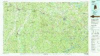
~ Jasper AL topo map, 1:100000 scale, 30 X 60 Minute, Historical, 1984, updated 1988
Jasper, Alabama, USGS topographic map dated 1984.
Includes geographic coordinates (latitude and longitude). This topographic map is suitable for hiking, camping, and exploring, or framing it as a wall map.
Printed on-demand using high resolution imagery, on heavy weight and acid free paper, or alternatively on a variety of synthetic materials.
Topos available on paper, Waterproof, Poly, or Tyvek. Usually shipping rolled, unless combined with other folded maps in one order.
- Product Number: USGS-5542617
- Free digital map download (high-resolution, GeoPDF): Jasper, Alabama (file size: 34 MB)
- Map Size: please refer to the dimensions of the GeoPDF map above
- Weight (paper map): ca. 55 grams
- Map Type: POD USGS Topographic Map
- Map Series: HTMC
- Map Verison: Historical
- Cell ID: 67732
- Scan ID: 305770
- Imprint Year: 1988
- Woodland Tint: Yes
- Aerial Photo Year: 1981
- Edit Year: 1984
- Datum: NAD27
- Map Projection: Universal Transverse Mercator
- Map published by United States Geological Survey
- Map Language: English
- Scanner Resolution: 600 dpi
- Map Cell Name: Jasper
- Grid size: 30 X 60 Minute
- Date on map: 1984
- Map Scale: 1:100000
- Geographical region: Alabama, United States
Neighboring Maps:
All neighboring USGS topo maps are available for sale online at a variety of scales.
Spatial coverage:
Topo map Jasper, Alabama, covers the geographical area associated the following places:
- Pine Tree Trailer Park - New Hope - Chapel Hill - Kilgore - Bessie Junction - Red Rock - Three Forks - Stough - Bankhead - Five Points - Texas - Booker Heights - Standard - Media - Tucker - Pocahontas - Calumet - Hayes Crossing - Boldo - Oak Hill - Samoset - Browntown - Guin - Hoagtown - Drummond - Short Camp - Dora - Snowtown - Ashcraft Corner - Pea Ridge - Powellville - Gu-Win - Bobo - Twilley Town - Bagley - Campbellville - Studdards Crossroads - Cedar Lake - Marietta - Gobblers Crossing - Flatwood - Red Star - Mountain Valley (historical) - Belk - Lupton - Whitson - Driftwood - Burnwell - South Lowell - Fayette - New Hope - Pendley - Thach - Bradleytown - Yerkwood - Lone Oak Subdivision - Crews Mobile Home Park - Bazemore - Bluff - New Lexington - Williamstown - Mill Creek Estates - Mansfield - Jerusalem - Newtonville - Marigold - Mount Hope - Kings Mill - Carbon Hill - Sunlight - Coon Creek - Praco - Gumbud - Gamble - Benoit - Frisco Quarters - Hudson Settlement - Palos - Maxine - Lynns Park - Briarcliff Estates - Lockhart (historical) - Slicklizzard - Holly Grove - Salem - Oakman - Eldridge - Sandtown - Gardiners Gin - Drifton - Big Ridge - Hillsdale - Pennsylvania Camp (historical) - Sardis - Macedonia - Old Town - Oak Hill Mobile Home Park - Fowlers Crossroads - Empire - Winfield
- Map Area ID: AREA3433.5-88-87
- Northwest corner Lat/Long code: USGSNW34-88
- Northeast corner Lat/Long code: USGSNE34-87
- Southwest corner Lat/Long code: USGSSW33.5-88
- Southeast corner Lat/Long code: USGSSE33.5-87
- Northern map edge Latitude: 34
- Southern map edge Latitude: 33.5
- Western map edge Longitude: -88
- Eastern map edge Longitude: -87


