
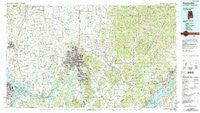
~ Huntsville AL topo map, 1:100000 scale, 30 X 60 Minute, Historical, 1984, updated 1988
Huntsville, Alabama, USGS topographic map dated 1984.
Includes geographic coordinates (latitude and longitude). This topographic map is suitable for hiking, camping, and exploring, or framing it as a wall map.
Printed on-demand using high resolution imagery, on heavy weight and acid free paper, or alternatively on a variety of synthetic materials.
Topos available on paper, Waterproof, Poly, or Tyvek. Usually shipping rolled, unless combined with other folded maps in one order.
- Product Number: USGS-5542615
- Free digital map download (high-resolution, GeoPDF): Huntsville, Alabama (file size: 30 MB)
- Map Size: please refer to the dimensions of the GeoPDF map above
- Weight (paper map): ca. 55 grams
- Map Type: POD USGS Topographic Map
- Map Series: HTMC
- Map Verison: Historical
- Cell ID: 67694
- Scan ID: 305769
- Imprint Year: 1988
- Woodland Tint: Yes
- Aerial Photo Year: 1981
- Edit Year: 1984
- Datum: NAD27
- Map Projection: Universal Transverse Mercator
- Map published by United States Geological Survey
- Map Language: English
- Scanner Resolution: 600 dpi
- Map Cell Name: Huntsville
- Grid size: 30 X 60 Minute
- Date on map: 1984
- Map Scale: 1:100000
- Geographical region: Alabama, United States
Neighboring Maps:
All neighboring USGS topo maps are available for sale online at a variety of scales.
Spatial coverage:
Topo map Huntsville, Alabama, covers the geographical area associated the following places:
- Elko - Rainbow Gap Estates - Mint Spring - Yorkshire - Woodall Place - English Village - Blue Spring Garden - Meridianville - Mountain Springs Estates - Madison Point - Bellemeade - Triana - Mount Lebanon - Bucks Canyon - Country Club Park - Locke Crossroads - Rocky Top Estates - Keel (historical) - Vestavia Estates - Greerton (historical) - Fisk - Rolling Woods - Alabama Fork - Sweetwater - Estaville (historical) - Country Club Estates - Sand Spring (historical) - Berrys (historical) - Big Cove - Batts Heights - Endsley Acres - Sandhurst Park - Willow Bend - Crestview Estates - Hollytree - Rocky Ridge - Sublett Mill - Mount Charron Estates - Cherrytree - Russell Village - Chimney Springs - Whiteside - Pisgah - Morris Crossroads - Hillwood - Lincoya - Moontown - Decatur - Lakewood - Dug Hill - Carey - The Highlands - Lakeview Beach - Redstone Park - Burningtree Mountain - Plevna - Saint Clair Store - Hickory Hills - Brookhurst - Cottonwood - Woodfin Mill - Gladstone - Ryland - Glen Park - Haden - Salem Corner - Aspel - Stone Ridge - Gentily Forest - Stag Run - Poplar Ridge - Pettusville - Narrows (historical) - Bailey Cove Estates - Hillsboro - Ardmore - Summit Place - Northside Acres - Hoover - Cherry Creek - Meadow Trace - Western Hills Estates - East Hampton - Cedargate - Parker - Decatur Junction - Bluff City - Maplewood - Echols Crossroads - Fleming Hills - Garth - Lily Flagg - Bel Air Estates - Country Village - Pine Dale - Edmonton Heights - Bell Factory - Cedar Valley - Davistown - Wooley Springs (historical)
- Map Area ID: AREA3534.5-87-86
- Northwest corner Lat/Long code: USGSNW35-87
- Northeast corner Lat/Long code: USGSNE35-86
- Southwest corner Lat/Long code: USGSSW34.5-87
- Southeast corner Lat/Long code: USGSSE34.5-86
- Northern map edge Latitude: 35
- Southern map edge Latitude: 34.5
- Western map edge Longitude: -87
- Eastern map edge Longitude: -86


