
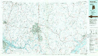
~ Huntsville AL topo map, 1:100000 scale, 30 X 60 Minute, Historical, 1984, updated 1986
Huntsville, Alabama, USGS topographic map dated 1984.
Includes geographic coordinates (latitude and longitude). This topographic map is suitable for hiking, camping, and exploring, or framing it as a wall map.
Printed on-demand using high resolution imagery, on heavy weight and acid free paper, or alternatively on a variety of synthetic materials.
Topos available on paper, Waterproof, Poly, or Tyvek. Usually shipping rolled, unless combined with other folded maps in one order.
- Product Number: USGS-5542613
- Free digital map download (high-resolution, GeoPDF): Huntsville, Alabama (file size: 21 MB)
- Map Size: please refer to the dimensions of the GeoPDF map above
- Weight (paper map): ca. 55 grams
- Map Type: POD USGS Topographic Map
- Map Series: HTMC
- Map Verison: Historical
- Cell ID: 67694
- Scan ID: 305768
- Imprint Year: 1986
- Aerial Photo Year: 1981
- Edit Year: 1984
- Datum: NAD27
- Map Projection: Universal Transverse Mercator
- Planimetric: Yes
- Map published by United States Geological Survey
- Map Language: English
- Scanner Resolution: 600 dpi
- Map Cell Name: Huntsville
- Grid size: 30 X 60 Minute
- Date on map: 1984
- Map Scale: 1:100000
- Geographical region: Alabama, United States
Neighboring Maps:
All neighboring USGS topo maps are available for sale online at a variety of scales.
Spatial coverage:
Topo map Huntsville, Alabama, covers the geographical area associated the following places:
- Bucksnort - South Sauty Subdivision - Pettusville - Owens Cross Roads - Fairview - West Decatur - Stone Ridge - Valhermoso Springs - Camelot - Pleasant Acres - Oakland - New Market - Laceys Spring - Nolan Hills - Jones Valley Estates - Carter Grove - Fairmount - Bel Air Estates - Flemington Heights - Oakwood - New Hope - Rainbow Gap Estates - Indian Trace - French Hill - Milan (historical) - English Village - Old Monrovia - Dug Hill - Brooksville - Sandhurst Park - Belmont - Hazel Green - Bell Factory - Swearengin - Indian Hills - Elkwood - Blue Spring Garden - Tupelo - Cedar Lake - Country Club Estates - Bonnie Doone - Lincoya - Sunset Cove - Wigginsville - South Park Estates - Cedar Valley - Burningtree Mountain - Lowe (historical) - Northwood - Priceville - Jackson Subdivision - Hobbs Island - Burgreen Gin - Tara - Estillfork - Humpton - Union Grove - Mercury - Madison Point - Northside Acres - Huntsville Hills - Vaughn Corners - The Highlands - Sommers South - Poplar Ridge - Regent Forest - Edgemont - Copeland - Lim Rock - Country Village - Mount Lebanon - Albany - Sweetwater - Grove Park - Big Cove - Byrd Springs - Fleming Hills - Woodall Place - Fisk - Francisco - Normal - Preston Subdivision - Cloverleaf - Sulphur Springs - Sardis Springs - Rocky Top Estates - Browns Corner - Oakwood - West Huntsville - Campbell - Skinem - Grant - Thach - Fannings Crossing - Bayside - Toney - Bonneville - Dodsonville (historical) - Mount Charron Estates - Belview Heights
- Map Area ID: AREA3534.5-87-86
- Northwest corner Lat/Long code: USGSNW35-87
- Northeast corner Lat/Long code: USGSNE35-86
- Southwest corner Lat/Long code: USGSSW34.5-87
- Southeast corner Lat/Long code: USGSSE34.5-86
- Northern map edge Latitude: 35
- Southern map edge Latitude: 34.5
- Western map edge Longitude: -87
- Eastern map edge Longitude: -86


