
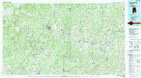
~ Greenville AL topo map, 1:100000 scale, 30 X 60 Minute, Historical, 1986, updated 1989
Greenville, Alabama, USGS topographic map dated 1986.
Includes geographic coordinates (latitude and longitude). This topographic map is suitable for hiking, camping, and exploring, or framing it as a wall map.
Printed on-demand using high resolution imagery, on heavy weight and acid free paper, or alternatively on a variety of synthetic materials.
Topos available on paper, Waterproof, Poly, or Tyvek. Usually shipping rolled, unless combined with other folded maps in one order.
- Product Number: USGS-5542603
- Free digital map download (high-resolution, GeoPDF): Greenville, Alabama (file size: 27 MB)
- Map Size: please refer to the dimensions of the GeoPDF map above
- Weight (paper map): ca. 55 grams
- Map Type: POD USGS Topographic Map
- Map Series: HTMC
- Map Verison: Historical
- Cell ID: 67610
- Scan ID: 305763
- Imprint Year: 1989
- Woodland Tint: Yes
- Aerial Photo Year: 1984
- Edit Year: 1986
- Datum: NAD27
- Map Projection: Universal Transverse Mercator
- Map published by United States Geological Survey
- Map Language: English
- Scanner Resolution: 600 dpi
- Map Cell Name: Greenville
- Grid size: 30 X 60 Minute
- Date on map: 1986
- Map Scale: 1:100000
- Geographical region: Alabama, United States
Neighboring Maps:
All neighboring USGS topo maps are available for sale online at a variety of scales.
Spatial coverage:
Topo map Greenville, Alabama, covers the geographical area associated the following places:
- Meadow Grove - Searcy - Meeksville - Saucer - Lees Park - Herbert - Ellis Crossroads - Curry - Henderson - Shreve - Shell - River Ridge - Good Hope - Briar Hill - Starlington - Fort Dale - Ivy Creek - New Hope - Logan - Weed Crossroad - Shady Grove - Georgiana - Grady - Pleasant Ridge - Little Oak - Pine Apple - Providence - Daisy - Mixonville - Merrill Mill - East Chapman - Petrey - Rhodes - Pigeon Creek - Sanders Hill - Highland Home - McKenzie - Liberty - Hallsville - Brantley - Centenary - Greenville - Shirleys Crossroads - Grace - Ridgeville - Brushy Creek - Town and Country Estates - Glasgow - Bullock - Center Ridge - Mulberry - Peacock (historical) - Olustee - Cooks Crossroads - Danielsville - Magnolia Shores - Halso Mill - Youngblood - Moodys Crossroads - Butler Springs - Mount Olive - Shacklesville - Leon - Avant - Macedonia - Spring Hill - Manningham - Ansley - Robinson Crossroads - Jack - Vera Cruz (historical) - Bolling - Palmyra - Monterey - Midway - Goshen - Zoar - Social Town - Wingard - Friendship - Pisgah - Beacon - Sardis - Bethel - Lapine - Chapman - Wald - Palmyra - Live Oak - Baltic - Garland - Sand Cut - Newby - Luverne - Rutledge - Joquin - Taylor - Forest Home - Saville - Bradleyton
- Map Area ID: AREA3231.5-87-86
- Northwest corner Lat/Long code: USGSNW32-87
- Northeast corner Lat/Long code: USGSNE32-86
- Southwest corner Lat/Long code: USGSSW31.5-87
- Southeast corner Lat/Long code: USGSSE31.5-86
- Northern map edge Latitude: 32
- Southern map edge Latitude: 31.5
- Western map edge Longitude: -87
- Eastern map edge Longitude: -86


