
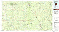
~ Citronelle AL topo map, 1:100000 scale, 30 X 60 Minute, Historical, 1984, updated 1984
Citronelle, Alabama, USGS topographic map dated 1984.
Includes geographic coordinates (latitude and longitude). This topographic map is suitable for hiking, camping, and exploring, or framing it as a wall map.
Printed on-demand using high resolution imagery, on heavy weight and acid free paper, or alternatively on a variety of synthetic materials.
Topos available on paper, Waterproof, Poly, or Tyvek. Usually shipping rolled, unless combined with other folded maps in one order.
- Product Number: USGS-5542591
- Free digital map download (high-resolution, GeoPDF): Citronelle, Alabama (file size: 22 MB)
- Map Size: please refer to the dimensions of the GeoPDF map above
- Weight (paper map): ca. 55 grams
- Map Type: POD USGS Topographic Map
- Map Series: HTMC
- Map Verison: Historical
- Cell ID: 72628
- Scan ID: 305757
- Imprint Year: 1984
- Woodland Tint: Yes
- Aerial Photo Year: 1981
- Edit Year: 1984
- Datum: NAD27
- Map Projection: Universal Transverse Mercator
- Planimetric: Yes
- Map published by United States Geological Survey
- Map Language: English
- Scanner Resolution: 600 dpi
- Map Cell Name: Citronelle
- Grid size: 30 X 60 Minute
- Date on map: 1984
- Map Scale: 1:100000
- Geographical region: Alabama, United States
Neighboring Maps:
All neighboring USGS topo maps are available for sale online at a variety of scales.
Spatial coverage:
Topo map Citronelle, Alabama, covers the geographical area associated the following places:
- Uniform - Toinette - Little Creek - Chastang - Brown Town - Dueitt - Pineola - Four Point - Sims Chapel - Hercules Station - Kittrell - Cortelyou - Mohoba (historical) - Hawthorn - Progress - Royce - Avera - Lambert Grove - Laton Hill - Brewer - Bucks - Fairford - Citronelle - Smithtown - Beaumont - Topton - Scoutshire Woods - Pisgah - Stage Coach Woods - Bothwell - Knobtown - Rounsaville - Bradley - Rutan - Old Avera - State Line - Hillman - Epworth - Mount Vernon - Carson City - Piave - Malcolm - Leakesville - Chestang - Seaboard - Walley - Russell - Hobson - Clark - Wagarville - Deer Park - Dwight - Leaf - Richton - New Wakefield - Bassetts Creek - Rhodes - Lambert - Benmore - Calvert - Blodgett - Sidney - Good Hope - Happy Hill - Jonathan - Reid Settlement - Ferguson - Sunflower - Tibbie - Chatom - Oak Grove - McLain - Henderson - Vernal - Yellow Pine - Neely - Hintonville - Wilson (historical) - McIntosh - McSwain - Sand Hill - East Side - Benjoe - Byrd - Vinegar Bend - Burbank - Adamsville (historical) - Kittrell - Mulberry - Escatawpa - Movico - Eret - Fruitdale
- Map Area ID: AREA31.531-89-88
- Northwest corner Lat/Long code: USGSNW31.5-89
- Northeast corner Lat/Long code: USGSNE31.5-88
- Southwest corner Lat/Long code: USGSSW31-89
- Southeast corner Lat/Long code: USGSSE31-88
- Northern map edge Latitude: 31.5
- Southern map edge Latitude: 31
- Western map edge Longitude: -89
- Eastern map edge Longitude: -88


