
~ Birmingham South AL topo map, 1:100000 scale, 30 X 60 Minute, Historical, 1984, updated 1985
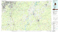
Birmingham South, Alabama, USGS topographic map dated 1984.
Includes geographic coordinates (latitude and longitude). This topographic map is suitable for hiking, camping, and exploring, or framing it as a wall map.
Printed on-demand using high resolution imagery, on heavy weight and acid free paper, or alternatively on a variety of synthetic materials.
Topos available on paper, Waterproof, Poly, or Tyvek. Usually shipping rolled, unless combined with other folded maps in one order.
- Product Number: USGS-5542585
- Free digital map download (high-resolution, GeoPDF): Birmingham South, Alabama (file size: 24 MB)
- Map Size: please refer to the dimensions of the GeoPDF map above
- Weight (paper map): ca. 55 grams
- Map Type: POD USGS Topographic Map
- Map Series: HTMC
- Map Verison: Historical
- Cell ID: 67142
- Scan ID: 305754
- Imprint Year: 1985
- Woodland Tint: Yes
- Aerial Photo Year: 1981
- Edit Year: 1984
- Datum: NAD27
- Map Projection: Universal Transverse Mercator
- Planimetric: Yes
- Map published by United States Geological Survey
- Map Language: English
- Scanner Resolution: 600 dpi
- Map Cell Name: Birmingham South
- Grid size: 30 X 60 Minute
- Date on map: 1984
- Map Scale: 1:100000
- Geographical region: Alabama, United States
Neighboring Maps:
All neighboring USGS topo maps are available for sale online at a variety of scales.
Spatial coverage:
Topo map Birmingham South, Alabama, covers the geographical area associated the following places:
- Grove Park - Abihka (historical) - Erharkers - Grasmere - Tanglewood - Navajo Hills - Williamsburg - Hatchet - Briarfield - Huntington Park - Thomas Acres - Pleasant Grove - Almont - Country Ridge Estates - Powderly - Phoenixville - Acton - Waldo - Goodwater - Lakeview Park - Eden Ridge - Willmay - Berneys - Comerdale - Dunbarton Oaks - Lindseys Crossing - Laceys Chapel - Wildwood Shores - Grasselli - Rice - Hudson Grove - Richmond Place - Ivanhoe - Renfroe - Phillips Estates - Woodward Junction - Pasqua - Thornhill - Navajo Pines - Varnons - Westfield - Walnut Grove - Broadmoor - Dargin - Belle Terre - Monte Bello - Weogufka - Kewahatchie - Tacoa - Woodland Hills - Belle Haven - South Calera - Edgemoor Estates - Whispering Oaks - Edgemont Park - North Highlands - Taylors Mill - Roselle - Eaglewood Estates - Odena - Crossgate - Rosedale - Anita - Brownville - Pleasant Hill - Oak Grove Estates - Shades Cliff - Erratta - Monte-Sano - Homewood - Glen Forest - Falliston - Saint Ives - Talladega Springs - Windsor Highlands - Vestwood Hills - Blueberry Estates - Woodmeadows - Gordon Heights - Loch Haven - Vestbrook Trace - Lakewood Hills - Garnsey Number 2 - Avalon Park - Edgewood - Vandiver - Shoal Run - Interurban Heights - Blue Ridge Estates - Shocco Springs - Pine Grove Village - Southpointe - Montclair - Beacon Hills - Montalla Acres - Talladega - Hidden Ridge - Hyde Park - Tarpley - Blue Creek Junction
- Map Area ID: AREA33.533-87-86
- Northwest corner Lat/Long code: USGSNW33.5-87
- Northeast corner Lat/Long code: USGSNE33.5-86
- Southwest corner Lat/Long code: USGSSW33-87
- Southeast corner Lat/Long code: USGSSE33-86
- Northern map edge Latitude: 33.5
- Southern map edge Latitude: 33
- Western map edge Longitude: -87
- Eastern map edge Longitude: -86


