
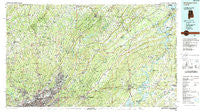
~ Birmingham North AL topo map, 1:100000 scale, 30 X 60 Minute, Historical, 1984, updated 1988
Birmingham North, Alabama, USGS topographic map dated 1984.
Includes geographic coordinates (latitude and longitude). This topographic map is suitable for hiking, camping, and exploring, or framing it as a wall map.
Printed on-demand using high resolution imagery, on heavy weight and acid free paper, or alternatively on a variety of synthetic materials.
Topos available on paper, Waterproof, Poly, or Tyvek. Usually shipping rolled, unless combined with other folded maps in one order.
- Product Number: USGS-5542583
- Free digital map download (high-resolution, GeoPDF): Birmingham North, Alabama (file size: 35 MB)
- Map Size: please refer to the dimensions of the GeoPDF map above
- Weight (paper map): ca. 55 grams
- Map Type: POD USGS Topographic Map
- Map Series: HTMC
- Map Verison: Historical
- Cell ID: 67141
- Scan ID: 305753
- Imprint Year: 1988
- Woodland Tint: Yes
- Aerial Photo Year: 1981
- Edit Year: 1984
- Datum: NAD27
- Map Projection: Universal Transverse Mercator
- Map published by United States Geological Survey
- Map Language: English
- Scanner Resolution: 600 dpi
- Map Cell Name: Birmingham North
- Grid size: 30 X 60 Minute
- Date on map: 1984
- Map Scale: 1:100000
- Geographical region: Alabama, United States
Neighboring Maps:
All neighboring USGS topo maps are available for sale online at a variety of scales.
Spatial coverage:
Topo map Birmingham North, Alabama, covers the geographical area associated the following places:
- Center Point Gardens - Mauldin (historical) - Woodmont - Jefferson Hills - Morgans Crossroads - Centercrest - Owenton - Winburn - Fairview - Monmouth - Griffitts Lake Shore Subdivision - Avon Park - Chetopa - Liberty Highlands - Forest Park - Whitney Junction - Marks Village - Fultondale Estates - Pawnee Heights - Cochran Springs (historical) - Spring Lake Estates - Misty Pines - Copper Springs - Roebuck Terrace - Walker Chapel - Roebuck Forest - Morningside - Avondale - Fairfield - Lakewood - Blossburg - Eastwood - Biscayne Highlands - Brompton - Nottingham - Northgate Trailer Park - Trotwood Park - Fountain Heights - Centerwood Estates - Franklin Gardens - Hood - Avondale Village - Sunrise East - Smiths Mill - Cherry Brook Estates - Tanyard - Battleground - Zion City - East Thomas - Ingle Terrace - Whites Chapel - Valleyhaven - Locust Fork - Nyota - Zion Heights - Vanderbilt - Westwood Trailer Court - Dogtown - England Isle - Scott City - Cotton Ridge - Parker Hudson Estates - Altamont Park - Saint Clair Springs - Caldwell - Douglasville - Oak Ridge - Wylam - Havilah Hills Estates - Exum - Adville - Crocker Junction - West Ensley - The Brick Store - Williams - Seloca - Pleasant Grove - Inland Junction - Nelson Heights - Roebuck - Cropwell - Moss Rock - Bremen - Beltona - Edgewater Junction - Reids - Kiowa - Brentwood - Nectar - Bentley Hills - Ayres Estates - Catatoga Estates - Hobson - Carl Smith Subdivision - Clear Springs - Nash (historical) - Oak Park - Woodlawn Heights - Huffman - Mount Olive
- Map Area ID: AREA3433.5-87-86
- Northwest corner Lat/Long code: USGSNW34-87
- Northeast corner Lat/Long code: USGSNE34-86
- Southwest corner Lat/Long code: USGSSW33.5-87
- Southeast corner Lat/Long code: USGSSE33.5-86
- Northern map edge Latitude: 34
- Southern map edge Latitude: 33.5
- Western map edge Longitude: -87
- Eastern map edge Longitude: -86


