
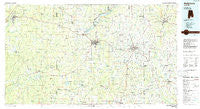
~ Andalusia AL topo map, 1:100000 scale, 30 X 60 Minute, Historical, 1986, updated 1986
Andalusia, Alabama, USGS topographic map dated 1986.
Includes geographic coordinates (latitude and longitude). This topographic map is suitable for hiking, camping, and exploring, or framing it as a wall map.
Printed on-demand using high resolution imagery, on heavy weight and acid free paper, or alternatively on a variety of synthetic materials.
Topos available on paper, Waterproof, Poly, or Tyvek. Usually shipping rolled, unless combined with other folded maps in one order.
- Product Number: USGS-5542567
- Free digital map download (high-resolution, GeoPDF): Andalusia, Alabama (file size: 20 MB)
- Map Size: please refer to the dimensions of the GeoPDF map above
- Weight (paper map): ca. 55 grams
- Map Type: POD USGS Topographic Map
- Map Series: HTMC
- Map Verison: Historical
- Cell ID: 67049
- Scan ID: 305745
- Imprint Year: 1986
- Woodland Tint: Yes
- Aerial Photo Year: 1984
- Edit Year: 1986
- Datum: NAD27
- Map Projection: Universal Transverse Mercator
- Planimetric: Yes
- Map published by United States Geological Survey
- Map Language: English
- Scanner Resolution: 600 dpi
- Map Cell Name: Andalusia
- Grid size: 30 X 60 Minute
- Date on map: 1986
- Map Scale: 1:100000
- Geographical region: Alabama, United States
Neighboring Maps:
All neighboring USGS topo maps are available for sale online at a variety of scales.
Spatial coverage:
Topo map Andalusia, Alabama, covers the geographical area associated the following places:
- Mount Union - Hacoda - Earlytown - Kinston - Samson - Old Town - Five Points - Travis Bridge - Lakeview Village Mobile Home Park - Heath - County Line - Shiloh - Eoda - Mount Carmel - Beulah - Brownville - Marietta - Dunns - Melrose - Gantt - Opine - Florala - Cohassett - Bullard Trailer Park - Fairview - Rawls - Evergreen - Rhump - Searight - Boykin - Piney Grove - Rock Hill - Rock Creek - Brooklyn - Horn Hill - Rome - Damascus - Pera - Estothel - Antioch - Valley of Shiloh - Nymph - Beck - Centerville - Weeks - River Falls - Rose Hill - Blue Springs - Straughn - Elba - Dixie - Blairs - Huckaville - Sanford - Rhoades - Montezuma (historical) - McRae - Hidden Acres Mobile Home Park - Babbie - Roberts - Lockhart - Libertyville - Duvall - Opp - Lee - Curtis - Friendship - Parker Springs - Ganer - Clearview - Ino - Basin - Brooks - Falco - Howells - Damascus - Sellersville - Harmony - Stedman - Fairfield - Perry Store - Carolina - Jay Villa - Lowery - Loango - Wing - Andalusia - Holley Store - Red Level - Johnsonville - Pine Level - Alberton - Stanley - Owassa - Paul - Chapel Hill - Coldwater - Rabb - Old Sparta - Onycha
- Map Area ID: AREA31.531-87-86
- Northwest corner Lat/Long code: USGSNW31.5-87
- Northeast corner Lat/Long code: USGSNE31.5-86
- Southwest corner Lat/Long code: USGSSW31-87
- Southeast corner Lat/Long code: USGSSE31-86
- Northern map edge Latitude: 31.5
- Southern map edge Latitude: 31
- Western map edge Longitude: -87
- Eastern map edge Longitude: -86


