
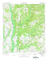
~ Hurley MS topo map, 1:62500 scale, 15 X 15 Minute, Historical, 1941, updated 1972
Hurley, Mississippi, USGS topographic map dated 1941.
Includes geographic coordinates (latitude and longitude). This topographic map is suitable for hiking, camping, and exploring, or framing it as a wall map.
Printed on-demand using high resolution imagery, on heavy weight and acid free paper, or alternatively on a variety of synthetic materials.
Topos available on paper, Waterproof, Poly, or Tyvek. Usually shipping rolled, unless combined with other folded maps in one order.
- Product Number: USGS-5542357
- Free digital map download (high-resolution, GeoPDF): Hurley, Mississippi (file size: 9 MB)
- Map Size: please refer to the dimensions of the GeoPDF map above
- Weight (paper map): ca. 55 grams
- Map Type: POD USGS Topographic Map
- Map Series: HTMC
- Map Verison: Historical
- Cell ID: 55608
- Scan ID: 305610
- Imprint Year: 1972
- Woodland Tint: Yes
- Survey Year: 1941
- Datum: NAD27
- Map Projection: Polyconic
- Map published by United States Geological Survey
- Map published by United States Army Corps of Engineers
- Map Language: English
- Scanner Resolution: 600 dpi
- Map Cell Name: Hurley
- Grid size: 15 X 15 Minute
- Date on map: 1941
- Map Scale: 1:62500
- Geographical region: Mississippi, United States
Neighboring Maps:
All neighboring USGS topo maps are available for sale online at a variety of scales.
Spatial coverage:
Topo map Hurley, Mississippi, covers the geographical area associated the following places:
- Hurley - Quail Ridge Park Mobile Home Park - Cloverdale - Seven Hills - Dawes Point - Petaluma - Dees - Slaughter Flat Landing - Dawes - Southside Mobile Home Park - Countryside Mobile Home Park - Cottage Park Estates - Cochran Place Mobile Home Park - Shady Oaks Mobile Home Park - Level Green Mobile Home Park - Howells Ferry Heights - Seven Hills Mobile Home Park - Saint Elmo - Scenic Hills - Jamar Mobile Home Park - Laws Landing Trailer Park - Tanner Williams - Western Hills Trailer Park - Union Church - Alderbrook - Big Point - Ponderosa
- Map Area ID: AREA30.7530.5-88.5-88.25
- Northwest corner Lat/Long code: USGSNW30.75-88.5
- Northeast corner Lat/Long code: USGSNE30.75-88.25
- Southwest corner Lat/Long code: USGSSW30.5-88.5
- Southeast corner Lat/Long code: USGSSE30.5-88.25
- Northern map edge Latitude: 30.75
- Southern map edge Latitude: 30.5
- Western map edge Longitude: -88.5
- Eastern map edge Longitude: -88.25


