
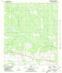
~ Steelwood Lake AL topo map, 1:24000 scale, 7.5 X 7.5 Minute, Historical, 1980, updated 1981
Steelwood Lake, Alabama, USGS topographic map dated 1980.
Includes geographic coordinates (latitude and longitude). This topographic map is suitable for hiking, camping, and exploring, or framing it as a wall map.
Printed on-demand using high resolution imagery, on heavy weight and acid free paper, or alternatively on a variety of synthetic materials.
Topos available on paper, Waterproof, Poly, or Tyvek. Usually shipping rolled, unless combined with other folded maps in one order.
- Product Number: USGS-5541489
- Free digital map download (high-resolution, GeoPDF): Steelwood Lake, Alabama (file size: 10 MB)
- Map Size: please refer to the dimensions of the GeoPDF map above
- Weight (paper map): ca. 55 grams
- Map Type: POD USGS Topographic Map
- Map Series: HTMC
- Map Verison: Historical
- Cell ID: 43058
- Scan ID: 305109
- Imprint Year: 1981
- Woodland Tint: Yes
- Aerial Photo Year: 1976
- Edit Year: 1980
- Field Check Year: 1976
- Datum: NAD27
- Map Projection: Transverse Mercator
- Map published by United States Geological Survey
- Map Language: English
- Scanner Resolution: 600 dpi
- Map Cell Name: Steelwood Lake
- Grid size: 7.5 X 7.5 Minute
- Date on map: 1980
- Map Scale: 1:24000
- Geographical region: Alabama, United States
Neighboring Maps:
All neighboring USGS topo maps are available for sale online at a variety of scales.
Spatial coverage:
Topo map Steelwood Lake, Alabama, covers the geographical area associated the following places:
- Williamson Farm Airport - Dyes Cemetery - Lake Kendrick - Juniper Creek - Baldwin County - Bertolli Lake - Styx River Church - WSKR-FM (Atmore) - Steelwood Lake - Fox Branch - Rosinton Church - WPMI-TV (Mobile) - Town of Loxley - Nuke Branch - Styx River Volunteer Fire Department - Flat Creek - Hinote Cemetery - Reedy Creek - Baswell Airport - Berry Field - Tennessee Coal and Iron Dam - Turpentine Camp - Steelwood Country Club - J P Bertolli Dam - Roans Creek - John Q Kendrick Dam - Old Mill Bridge - Greenwood Spring Branch
- Map Area ID: AREA30.7530.625-87.75-87.625
- Northwest corner Lat/Long code: USGSNW30.75-87.75
- Northeast corner Lat/Long code: USGSNE30.75-87.625
- Southwest corner Lat/Long code: USGSSW30.625-87.75
- Southeast corner Lat/Long code: USGSSE30.625-87.625
- Northern map edge Latitude: 30.75
- Southern map edge Latitude: 30.625
- Western map edge Longitude: -87.75
- Eastern map edge Longitude: -87.625


