
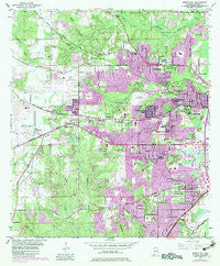
~ Spring Hill AL topo map, 1:24000 scale, 7.5 X 7.5 Minute, Historical, 1953, updated 1983
Spring Hill, Alabama, USGS topographic map dated 1953.
Includes geographic coordinates (latitude and longitude). This topographic map is suitable for hiking, camping, and exploring, or framing it as a wall map.
Printed on-demand using high resolution imagery, on heavy weight and acid free paper, or alternatively on a variety of synthetic materials.
Topos available on paper, Waterproof, Poly, or Tyvek. Usually shipping rolled, unless combined with other folded maps in one order.
- Product Number: USGS-5541437
- Free digital map download (high-resolution, GeoPDF): Spring Hill, Alabama (file size: 17 MB)
- Map Size: please refer to the dimensions of the GeoPDF map above
- Weight (paper map): ca. 55 grams
- Map Type: POD USGS Topographic Map
- Map Series: HTMC
- Map Verison: Historical
- Cell ID: 42627
- Scan ID: 305082
- Imprint Year: 1983
- Woodland Tint: Yes
- Visual Version Number: 1
- Photo Revision Year: 1982
- Aerial Photo Year: 1981
- Edit Year: 1982
- Survey Year: 1940
- Datum: NAD27
- Map Projection: Polyconic
- Map published by United States Geological Survey
- Map Language: English
- Scanner Resolution: 600 dpi
- Map Cell Name: Spring Hill
- Grid size: 7.5 X 7.5 Minute
- Date on map: 1953
- Map Scale: 1:24000
- Geographical region: Alabama, United States
Neighboring Maps:
All neighboring USGS topo maps are available for sale online at a variety of scales.
Spatial coverage:
Topo map Spring Hill, Alabama, covers the geographical area associated the following places:
- Forest Hill - Timbers - Rolling Acres - Sunset Ranch - Wheelerville - Chesterfield Estates - Ridgewood Trailer Park - Alpine Hills - Cambridge Estates - Regency - The Palms Trailer Park - Canebrake - Country Squire Estates - Pine Oaks Mobile Home Park - Magnolia Pointe Manufactured Home Community - Acropolis Heights - Edgefield - Pleasanton Hills Trailer Park - Pine Acres Trailer Park - Country Club Village - West Hill - Cottage Hill Estates - Orchard - Cottage Hill - Macy Trailer Park - Granato Estates - Forest Highlands - Bellwood - Park Forest - Old Government Mobile Home Park - Burma Hills - Pine Grove - Scenic West Estates - Carriage Hills - Huntleigh Woods - Browns Recreational Vehicle and Mobile Home Park - Spring Hill - Overlook Estates - Parkview Estates - Skyland Park Estates - Winthrop Square - Deerwood - Sugar Creek - Aces Trailer Park - Pleasant Mobile Home Park - Camelia Trace Mobile Home Park - Park Place of West Mobile Trailer Park - Pine Run - Smithfield - Glen Acres - Bryson Acres Trailer Park - Southridge - Spring Valley - Princeton Woods - Nix Mobile Home Park - Creekwood - El Monte - Eau Claire Estates - Oakwood Estates - Jackson Heights - Lebaron Woods - Wildwood Heights - Ramada Estates - Green Park West Mobile Home Park - Country Club Estates - Coronado Estates - Belle Chene - Hillsdale Heights
- Map Area ID: AREA30.7530.625-88.25-88.125
- Northwest corner Lat/Long code: USGSNW30.75-88.25
- Northeast corner Lat/Long code: USGSNE30.75-88.125
- Southwest corner Lat/Long code: USGSSW30.625-88.25
- Southeast corner Lat/Long code: USGSSE30.625-88.125
- Northern map edge Latitude: 30.75
- Southern map edge Latitude: 30.625
- Western map edge Longitude: -88.25
- Eastern map edge Longitude: -88.125


