
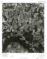
~ Mount Meigs SW AL topo map, 1:24000 scale, 7.5 X 7.5 Minute, Historical, 1975, updated 1977
Mount Meigs SW, Alabama, USGS topographic map dated 1975.
Includes geographic coordinates (latitude and longitude). This topographic map is suitable for hiking, camping, and exploring, or framing it as a wall map.
Printed on-demand using high resolution imagery, on heavy weight and acid free paper, or alternatively on a variety of synthetic materials.
Topos available on paper, Waterproof, Poly, or Tyvek. Usually shipping rolled, unless combined with other folded maps in one order.
- Product Number: USGS-5540537
- Free digital map download (high-resolution, GeoPDF): Mount Meigs SW, Alabama (file size: 21 MB)
- Map Size: please refer to the dimensions of the GeoPDF map above
- Weight (paper map): ca. 55 grams
- Map Type: POD USGS Topographic Map
- Map Series: HTMC
- Map Verison: Historical
- Cell ID: 2368
- Scan ID: 304622
- Imprint Year: 1977
- Aerial Photo Year: 1975
- Datum: NAD27
- Map Projection: Transverse Mercator
- Orthophoto: Quad
- Map published by United States Geological Survey
- Keywords: Nonstandard Press Run
- Map Language: English
- Scanner Resolution: 600 dpi
- Map Cell Name: Barachias
- Grid size: 7.5 X 7.5 Minute
- Date on map: 1975
- Map Scale: 1:24000
- Geographical region: Alabama, United States
Neighboring Maps:
All neighboring USGS topo maps are available for sale online at a variety of scales.
Spatial coverage:
Topo map Mount Meigs SW, Alabama, covers the geographical area associated the following places:
- Hunters Point - Montwood Estates - Green Acres - Eastwood Farms - Mosswood - Brighton Estates - Bell Meadows - Carol Villa - Foxwood - Bellwood Estates - Regency Park - Macedonia - Georgetown - Woodley Meadows - Bellwood Plantation - Monterey Park - Halcyon - Warrenton Estates - Pine Forest Estates - Olde Acres - Pinedale - Ranchette Estates - Young Place - Perrys Mill - Brookwood Estates - Woodland Hills - Heatherton Heights - Regency Forest - Virginia Estates - Carriage Hills - Executive Park - Rosemary - Bell Station - Barachias
- Map Area ID: AREA32.37532.25-86.25-86.125
- Northwest corner Lat/Long code: USGSNW32.375-86.25
- Northeast corner Lat/Long code: USGSNE32.375-86.125
- Southwest corner Lat/Long code: USGSSW32.25-86.25
- Southeast corner Lat/Long code: USGSSE32.25-86.125
- Northern map edge Latitude: 32.375
- Southern map edge Latitude: 32.25
- Western map edge Longitude: -86.25
- Eastern map edge Longitude: -86.125


