
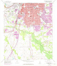
~ Montgomery South AL topo map, 1:24000 scale, 7.5 X 7.5 Minute, Historical, 1958, updated 1973
Montgomery South, Alabama, USGS topographic map dated 1958.
Includes geographic coordinates (latitude and longitude). This topographic map is suitable for hiking, camping, and exploring, or framing it as a wall map.
Printed on-demand using high resolution imagery, on heavy weight and acid free paper, or alternatively on a variety of synthetic materials.
Topos available on paper, Waterproof, Poly, or Tyvek. Usually shipping rolled, unless combined with other folded maps in one order.
- Product Number: USGS-5540485
- Free digital map download (high-resolution, GeoPDF): Montgomery South, Alabama (file size: 12 MB)
- Map Size: please refer to the dimensions of the GeoPDF map above
- Weight (paper map): ca. 55 grams
- Map Type: POD USGS Topographic Map
- Map Series: HTMC
- Map Verison: Historical
- Cell ID: 29965
- Scan ID: 304596
- Imprint Year: 1973
- Woodland Tint: Yes
- Photo Revision Year: 1972
- Aerial Photo Year: 1972
- Field Check Year: 1958
- Datum: NAD27
- Map Projection: Polyconic
- Map published by United States Geological Survey
- Map Language: English
- Scanner Resolution: 600 dpi
- Map Cell Name: Montgomery South
- Grid size: 7.5 X 7.5 Minute
- Date on map: 1958
- Map Scale: 1:24000
- Geographical region: Alabama, United States
Neighboring Maps:
All neighboring USGS topo maps are available for sale online at a variety of scales.
Spatial coverage:
Topo map Montgomery South, Alabama, covers the geographical area associated the following places:
- Village West - Bellemeade - Clubview Estates - Ridgecrest - Seth Johnson Estates - Cross Creek - Mayfair - Lynwood Terrace - Hillwood - Westview Gardens - Woodcrest Estates - Spring Park - Carver Park - Spring Valley - Vaughan Meadows - Southlawn East - Oak Park - Windwood - Druid Hills - Ridgefield - Western Hills - Southmont - McGehees - Valley Whispers - West End - Gibbs Village - Wildwood - Gladlane Estates - Prairie View Estates - McGehee Estates - Sunshine Acres - Steiner - Westgate - Mobile Heights - Perry Hills - Southern Meadows - Normandale - Memorial Heights - Powelldale - Woodley Park - English Village - Brickdale Estates - Greater Washington Park - Elsmeade - Maxwell Heights - Washington Park - Governors Estates - Cloverland - Young Forte Village - Highland Village - Arlington - Lagos del Sol - Hope Hull - Cleveland Meadows - Edgemont Heights - Cloverdale - Southlawn - Lakeview Heights - Montgomery - Lynndale - Grove Hill - Rosemond Estates - Brentwood - Wiley - Woodley East Estates - Hillwood West - Gay Meadows
- Map Area ID: AREA32.37532.25-86.375-86.25
- Northwest corner Lat/Long code: USGSNW32.375-86.375
- Northeast corner Lat/Long code: USGSNE32.375-86.25
- Southwest corner Lat/Long code: USGSSW32.25-86.375
- Southeast corner Lat/Long code: USGSSE32.25-86.25
- Northern map edge Latitude: 32.375
- Southern map edge Latitude: 32.25
- Western map edge Longitude: -86.375
- Eastern map edge Longitude: -86.25


