
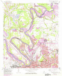
~ Montgomery North AL topo map, 1:24000 scale, 7.5 X 7.5 Minute, Historical, 1958, updated 1982
Montgomery North, Alabama, USGS topographic map dated 1958.
Includes geographic coordinates (latitude and longitude). This topographic map is suitable for hiking, camping, and exploring, or framing it as a wall map.
Printed on-demand using high resolution imagery, on heavy weight and acid free paper, or alternatively on a variety of synthetic materials.
Topos available on paper, Waterproof, Poly, or Tyvek. Usually shipping rolled, unless combined with other folded maps in one order.
- Product Number: USGS-5540477
- Free digital map download (high-resolution, GeoPDF): Montgomery North, Alabama (file size: 14 MB)
- Map Size: please refer to the dimensions of the GeoPDF map above
- Weight (paper map): ca. 55 grams
- Map Type: POD USGS Topographic Map
- Map Series: HTMC
- Map Verison: Historical
- Cell ID: 29964
- Scan ID: 304592
- Imprint Year: 1982
- Woodland Tint: Yes
- Photo Revision Year: 1981
- Aerial Photo Year: 1979
- Edit Year: 1981
- Field Check Year: 1958
- Datum: NAD27
- Map Projection: Polyconic
- Map published by United States Geological Survey
- Map Language: English
- Scanner Resolution: 600 dpi
- Map Cell Name: Montgomery North
- Grid size: 7.5 X 7.5 Minute
- Date on map: 1958
- Map Scale: 1:24000
- Geographical region: Alabama, United States
Neighboring Maps:
All neighboring USGS topo maps are available for sale online at a variety of scales.
Spatial coverage:
Topo map Montgomery North, Alabama, covers the geographical area associated the following places:
- King Hill - Kilby - Five Points - North Montgomery - Kingswood - Millbrook - Morningview - Great Oaks - Brookview Manor - Sunset Park Estates - Chisholm - Open Acres - Garden Square - North Pass - Coosada - Highland Gardens - Forest Hills - Boylston - Sherwood - Flatwood - Park Manor - Eastern Meadows - Hillcrest - Rosemont Heights - Sheridan Heights - Capitol Heights - New Town - Highpoint Estates - Wareingwood - Prattville Junction - Rose Hill - Clisby Park - Pine Brook Estates - Pecan Grove Estates - Jacksons Lake
- Map Area ID: AREA32.532.375-86.375-86.25
- Northwest corner Lat/Long code: USGSNW32.5-86.375
- Northeast corner Lat/Long code: USGSNE32.5-86.25
- Southwest corner Lat/Long code: USGSSW32.375-86.375
- Southeast corner Lat/Long code: USGSSE32.375-86.25
- Northern map edge Latitude: 32.5
- Southern map edge Latitude: 32.375
- Western map edge Longitude: -86.375
- Eastern map edge Longitude: -86.25


