
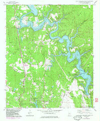
~ Lake Tuscaloosa South AL topo map, 1:24000 scale, 7.5 X 7.5 Minute, Historical, 1978, updated 1983
Lake Tuscaloosa South, Alabama, USGS topographic map dated 1978.
Includes geographic coordinates (latitude and longitude). This topographic map is suitable for hiking, camping, and exploring, or framing it as a wall map.
Printed on-demand using high resolution imagery, on heavy weight and acid free paper, or alternatively on a variety of synthetic materials.
Topos available on paper, Waterproof, Poly, or Tyvek. Usually shipping rolled, unless combined with other folded maps in one order.
- Product Number: USGS-5540015
- Free digital map download (high-resolution, GeoPDF): Lake Tuscaloosa South, Alabama (file size: 14 MB)
- Map Size: please refer to the dimensions of the GeoPDF map above
- Weight (paper map): ca. 55 grams
- Map Type: POD USGS Topographic Map
- Map Series: HTMC
- Map Verison: Historical
- Cell ID: 24684
- Scan ID: 304358
- Imprint Year: 1983
- Woodland Tint: Yes
- Photo Revision Year: 1982
- Aerial Photo Year: 1981
- Edit Year: 1982
- Field Check Year: 1975
- Datum: NAD27
- Map Projection: Transverse Mercator
- Map published by United States Geological Survey
- Map Language: English
- Scanner Resolution: 600 dpi
- Map Cell Name: Lake Tuscaloosa South
- Grid size: 7.5 X 7.5 Minute
- Date on map: 1978
- Map Scale: 1:24000
- Geographical region: Alabama, United States
Neighboring Maps:
All neighboring USGS topo maps are available for sale online at a variety of scales.
Spatial coverage:
Topo map Lake Tuscaloosa South, Alabama, covers the geographical area associated the following places:
- Northwood Forest - Batchelor Subdivision - Four Winds - Hamner Estates - Lakeland Forest - Northcliff - Huntington Place - Lakewood - Willow Point - Candlewood - Loganwood - Mariners Cove - Carolwood Estates - North River Country Club Estates - Wood Village - Clearwater Estates - Carolwood - Wood Estates - Bridgeview - Burnt Pine - Demarest - Chestnut Hill - Cherokee Shores - Monterey Drive - Sartains Ridgecrest Subdivision - Telmar Subdivision - Edwardian Place - Northwood Lake - Lake Hills North - Vista Granda - Lavender Acres - Lakeview Estates - Pinedale - North Haven - Yacht Club Bay - High Cliff - Lake Cove - Stonehedge Cliffs - Appling Bend - Smoke Rise - Graceland Acres - Flatwoods - Cove Park - Chewalla - Lakeview Manor - North Valley Acres - Northcrest - Briarcliff - Camile Terrace - Lake Front Village - Georgena Terrace - Stonehedge - Driftwood Estates - Beacon Point
- Map Area ID: AREA33.37533.25-87.625-87.5
- Northwest corner Lat/Long code: USGSNW33.375-87.625
- Northeast corner Lat/Long code: USGSNE33.375-87.5
- Southwest corner Lat/Long code: USGSSW33.25-87.625
- Southeast corner Lat/Long code: USGSSE33.25-87.5
- Northern map edge Latitude: 33.375
- Southern map edge Latitude: 33.25
- Western map edge Longitude: -87.625
- Eastern map edge Longitude: -87.5


