
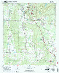
~ Alabaster AL topo map, 1:24000 scale, 7.5 X 7.5 Minute, Historical, 1980, updated 1984
Alabaster, Alabama, USGS topographic map dated 1980.
Includes geographic coordinates (latitude and longitude). This topographic map is suitable for hiking, camping, and exploring, or framing it as a wall map.
Printed on-demand using high resolution imagery, on heavy weight and acid free paper, or alternatively on a variety of synthetic materials.
Topos available on paper, Waterproof, Poly, or Tyvek. Usually shipping rolled, unless combined with other folded maps in one order.
- Product Number: USGS-5537519
- Free digital map download (high-resolution, GeoPDF): Alabaster, Alabama (file size: 11 MB)
- Map Size: please refer to the dimensions of the GeoPDF map above
- Weight (paper map): ca. 55 grams
- Map Type: POD USGS Topographic Map
- Map Series: HTMC
- Map Verison: Historical
- Cell ID: 69141
- Scan ID: 303082
- Imprint Year: 1984
- Woodland Tint: Yes
- Visual Version Number: 2
- Aerial Photo Year: 1974
- Edit Year: 1980
- Field Check Year: 1975
- Datum: NAD27
- Map Projection: Transverse Mercator
- Map published by United States Geological Survey
- Map Language: English
- Scanner Resolution: 600 dpi
- Map Cell Name: Alabaster
- Grid size: 7.5 X 7.5 Minute
- Date on map: 1980
- Map Scale: 1:24000
- Geographical region: Alabama, United States
Neighboring Maps:
All neighboring USGS topo maps are available for sale online at a variety of scales.
Spatial coverage:
Topo map Alabaster, Alabama, covers the geographical area associated the following places:
- Saginaw - Mission Hills - Glen Forest - Underwood - Woodland Hills - Elliotsville - Country Hills - Siluria - Alabaster - Monte Bello - Maylene - Stems - Dargin - Scottsdale - Ivanhoe - Dogwood - Eaglewood Estates - Montalla Acres - Moores Crossroads - Willow Glen - Meadow Green - Varnons - Camp Branch - Ryan - Willmay - Verlie - Old Maylene - Longview - Brantleyville - Pasqua
- Map Area ID: AREA33.2533.125-86.875-86.75
- Northwest corner Lat/Long code: USGSNW33.25-86.875
- Northeast corner Lat/Long code: USGSNE33.25-86.75
- Southwest corner Lat/Long code: USGSSW33.125-86.875
- Southeast corner Lat/Long code: USGSSE33.125-86.75
- Northern map edge Latitude: 33.25
- Southern map edge Latitude: 33.125
- Western map edge Longitude: -86.875
- Eastern map edge Longitude: -86.75


