
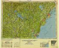
~ Portland ME topo map, 1:250000 scale, 1 X 2 Degree, Historical, 1949, updated 1949
Portland, Maine, USGS topographic map dated 1949.
Includes geographic coordinates (latitude and longitude). This topographic map is suitable for hiking, camping, and exploring, or framing it as a wall map.
Printed on-demand using high resolution imagery, on heavy weight and acid free paper, or alternatively on a variety of synthetic materials.
Topos available on paper, Waterproof, Poly, or Tyvek. Usually shipping rolled, unless combined with other folded maps in one order.
- Product Number: USGS-5537475
- Free digital map download (high-resolution, GeoPDF): Portland, Maine (file size: 16 MB)
- Map Size: please refer to the dimensions of the GeoPDF map above
- Weight (paper map): ca. 55 grams
- Map Type: POD USGS Topographic Map
- Map Series: HTMC
- Map Verison: Historical
- Cell ID: 68970
- Scan ID: 807050
- Imprint Year: 1949
- Woodland Tint: Yes
- Aerial Photo Year: 1942
- Datum: NAD27
- Map Projection: Transverse Mercator
- Map published by United States Army Corps of Engineers
- Map published by United States Army
- Map Language: English
- Scanner Resolution: 508 dpi
- Map Cell Name: Portland
- Grid size: 1 X 2 Degree
- Date on map: 1949
- Map Scale: 1:250000
- Geographical region: Maine, United States
Neighboring Maps:
All neighboring USGS topo maps are available for sale online at a variety of scales.
Spatial coverage:
Topo map Portland, Maine, covers the geographical area associated the following places:
- Foyes Corner - Mosher Corner - North Groton - East Weare (historical) - Cumberland Foreside - Edes Falls - Massabesic - Airport Village - Allens Mills - Wakefield - Ligonia - Pendleton Beach - Laskey Corner - Chebeague Island - Seabury - Libbytown - Severance - Dog Corner - South Parsonsfield - Varney Crossing - Cummings - East Brownfield - Deering Junction - Snyders Hill - East Limington - Candia Four Corners - Interlaken Park - Goodwins Mills - Todds Corners - Shapleigh - West Epping - Greenland - Miller Corner - East Andover - Kelleys Corner - Epping - Deerfield - Wolfeboro Center - Dorchester - Effingham - East Eliot - West Durham - Concord Manor - Waites Landing - Bow Junction - Heads Corner - South Tamworth - Yale Estates - Campton Hollow - Bar Mills - South Lebanon - Rockingham - Pejepscot - Nuttings Beach - Allenstown Elementary School - Upper Gloucester - Rosemont - Stratham - Perrys Corner - Creek Area - Pannaway Manor - Bucks Corner - Little Falls - West Baldwin - Elizabeth Park - Waterboro - Great Diamond Island Landing - Warren - Ossipee Lake Shores - Crossman Corner - Strafford - Sutton - McKinley Estates - North Wakefield - Wildwood Village - Cumberland Center Station - Dunegrass Golf Community - Cornish - Two Trails - Jewett - Kennard Corner - Long Island - Wolfeboro - Clinton Grove - Pleasant Hill - Martin - Shaw Mills - South Acton - Wildes District - West Lebanon - Portsmouth - Davis - North Falmouth - Sanbornton - Loveitts Field - Crockett Corner - Bradford - Glendale - Beech Ridge - Camp Hedding
- Map Area ID: AREA4443-72-70
- Northwest corner Lat/Long code: USGSNW44-72
- Northeast corner Lat/Long code: USGSNE44-70
- Southwest corner Lat/Long code: USGSSW43-72
- Southeast corner Lat/Long code: USGSSE43-70
- Northern map edge Latitude: 44
- Southern map edge Latitude: 43
- Western map edge Longitude: -72
- Eastern map edge Longitude: -70


