
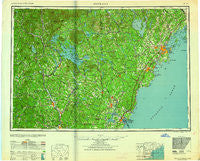
~ Portland ME topo map, 1:250000 scale, 1 X 2 Degree, Historical, 1959, updated 1959
Portland, Maine, USGS topographic map dated 1959.
Includes geographic coordinates (latitude and longitude). This topographic map is suitable for hiking, camping, and exploring, or framing it as a wall map.
Printed on-demand using high resolution imagery, on heavy weight and acid free paper, or alternatively on a variety of synthetic materials.
Topos available on paper, Waterproof, Poly, or Tyvek. Usually shipping rolled, unless combined with other folded maps in one order.
- Product Number: USGS-5537473
- Free digital map download (high-resolution, GeoPDF): Portland, Maine (file size: 15 MB)
- Map Size: please refer to the dimensions of the GeoPDF map above
- Weight (paper map): ca. 55 grams
- Map Type: POD USGS Topographic Map
- Map Series: HTMC
- Map Verison: Historical
- Cell ID: 68970
- Scan ID: 807049
- Imprint Year: 1959
- Woodland Tint: Yes
- Aerial Photo Year: 1942
- Survey Year: 1956
- Datum: NAD27
- Map Projection: Transverse Mercator
- Map published by United States Army Corps of Engineers
- Map published by United States Army
- Map Language: English
- Scanner Resolution: 508 dpi
- Map Cell Name: Portland
- Grid size: 1 X 2 Degree
- Date on map: 1959
- Map Scale: 1:250000
- Geographical region: Maine, United States
Neighboring Maps:
All neighboring USGS topo maps are available for sale online at a variety of scales.
Spatial coverage:
Topo map Portland, Maine, covers the geographical area associated the following places:
- Goffstown - Long Beach - Remick Corners - Milton - Airport Village - Bucks Corner - Chickville - Suncook - Shaker Village - Quincy - Emery Mills - Perrys Corner - Epping - Center Strafford - Varney Crossing - Northwood Center - Davis - Moody Beach - Smiths Corner - West Durham - Wells Beach Station - Winona - Beebe River - Meeting House Hill - Whites Corner - West Andover - Pejepscot - Piscataqua - South Weare - Camp Ellis - Tatnic - Saco - North Scarborough - Dingit Corner - Bow Junction - Mast Landing - Wells Beach - West Kennebunk - Union - Garrison Hills Estates - West Franklin - Prides Corner - Eight Corners - Kelwyn Park - East Hebron - Danbury - Roberts Corner - East Alton - Franklin - Bedell Crossing - Blue Point - Winnicut Mills - Highpine - Maplewood - New Castle - North Lebanon - Rumney - Newtown - Wells - Rye - Deering - Silver Lake - Rye North Beach - Epsom - Grays Corner - West Center Harbor - Martins Corner - Stroudwater - Salmon Falls - East Springfield - Convene - Rankins Mill - Brixham - Cousins Island - Pine Park - South Naples - Miller Corner - North Chester - South Gray - Falmouth Foreside - Ellsworth - Center Sandwich - Middleton Corners - Berrys Corner - Gonic - Town House Corners - North Sutton - Town Landing - Cape Cottage - Gag Corner - Durham - Westbrook - Laskey Corner - Fessenden (historical) - Breezy Point - Lyford Crossing - Fort Levett - Plummer Mill - Groveville - Kittery
- Map Area ID: AREA4443-72-70
- Northwest corner Lat/Long code: USGSNW44-72
- Northeast corner Lat/Long code: USGSNE44-70
- Southwest corner Lat/Long code: USGSSW43-72
- Southeast corner Lat/Long code: USGSSE43-70
- Northern map edge Latitude: 44
- Southern map edge Latitude: 43
- Western map edge Longitude: -72
- Eastern map edge Longitude: -70


