
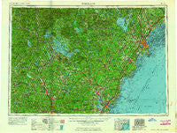
~ Portland ME topo map, 1:250000 scale, 1 X 2 Degree, Historical, 1956, updated 1963
Portland, Maine, USGS topographic map dated 1956.
Includes geographic coordinates (latitude and longitude). This topographic map is suitable for hiking, camping, and exploring, or framing it as a wall map.
Printed on-demand using high resolution imagery, on heavy weight and acid free paper, or alternatively on a variety of synthetic materials.
Topos available on paper, Waterproof, Poly, or Tyvek. Usually shipping rolled, unless combined with other folded maps in one order.
- Product Number: USGS-5537469
- Free digital map download (high-resolution, GeoPDF): Portland, Maine (file size: 17 MB)
- Map Size: please refer to the dimensions of the GeoPDF map above
- Weight (paper map): ca. 55 grams
- Map Type: POD USGS Topographic Map
- Map Series: HTMC
- Map Verison: Historical
- Cell ID: 68970
- Scan ID: 807047
- Imprint Year: 1963
- Woodland Tint: Yes
- Field Check Year: 1956
- Datum: Unstated
- Map Projection: Transverse Mercator
- Map published by United States Army Corps of Engineers
- Map published by United States Army
- Map Language: English
- Scanner Resolution: 508 dpi
- Map Cell Name: Portland
- Grid size: 1 X 2 Degree
- Date on map: 1956
- Map Scale: 1:250000
- Geographical region: Maine, United States
Neighboring Maps:
All neighboring USGS topo maps are available for sale online at a variety of scales.
Spatial coverage:
Topo map Portland, Maine, covers the geographical area associated the following places:
- Cliff Island Landing - Fessenden (historical) - West Hopkinton - Beebe River - Merepoint - Interlaken Park - Shaker Village - Wells - West Pownal - Windham Hill - Woodfords Corner - Pownal Center - East Eliot - Eliot - Alfred Mills - Bradford - Walnut Hill - Perkins Town - Wildes District - Waites Landing - South Portland - Perrys Corner - Colonial Pines - Pleasant Hill - Cape Cottage - Crockett Corner - Bow Junction - Gilmanton - Cape Porpoise - Two Trails - Kennebunk Beach - West Andover - Chicopee - Oak Terrace - Sanbornville - Piscataqua - Center Tuftonboro - South Gray - Wentworth Hill - Sandwich Landing - High Pasture - Grays Corner - Goose Rocks Beach - Eight Corners - New Hampton - Loudon - York Corner - Boscawen - Biddeford - South Casco - Willard Square - Hillsboro Lower Village - Growstown - Gates Corner - Snyders Hill - Passaconaway - Bear Island - South Berwick - Bennett Corners - Northwood - Summit View Park (historical) - North Groton - Popeville - West Falmouth (historical) - Stinson Lake - Rye - Crocketts Crossing - Old Orchard Beach - South Acton - Shaws Hill - Pickering - Dimond - Heads Corner - Guinea Corner - Baker Corner - Webster Place - Kittery - Lone Creek Village (historical) - Union Falls - Dunegrass Golf Community - Berwick - Upper Gloucester - Wells Branch - South Weare - East Hebron - Coburn - Breakfast Hill - Little Diamond Island Landing - Cheever - Scribners Corner - Elmwood - Mee Corners - Lords Hill (historical) - Center Strafford - Ferry Beach - York Beach - Buxton Center - Groton - East Bear Island - State Landing
- Map Area ID: AREA4443-72-70
- Northwest corner Lat/Long code: USGSNW44-72
- Northeast corner Lat/Long code: USGSNE44-70
- Southwest corner Lat/Long code: USGSSW43-72
- Southeast corner Lat/Long code: USGSSE43-70
- Northern map edge Latitude: 44
- Southern map edge Latitude: 43
- Western map edge Longitude: -72
- Eastern map edge Longitude: -70


