
~ Portland ME topo map, 1:250000 scale, 1 X 2 Degree, Historical, 1956, updated 1975
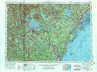
Portland, Maine, USGS topographic map dated 1956.
Includes geographic coordinates (latitude and longitude). This topographic map is suitable for hiking, camping, and exploring, or framing it as a wall map.
Printed on-demand using high resolution imagery, on heavy weight and acid free paper, or alternatively on a variety of synthetic materials.
Topos available on paper, Waterproof, Poly, or Tyvek. Usually shipping rolled, unless combined with other folded maps in one order.
- Product Number: USGS-5537467
- Free digital map download (high-resolution, GeoPDF): Portland, Maine (file size: 22 MB)
- Map Size: please refer to the dimensions of the GeoPDF map above
- Weight (paper map): ca. 55 grams
- Map Type: POD USGS Topographic Map
- Map Series: HTMC
- Map Verison: Historical
- Cell ID: 68970
- Scan ID: 807046
- Imprint Year: 1975
- Woodland Tint: Yes
- Aerial Photo Year: 1972
- Edit Year: 1972
- Field Check Year: 1956
- Datum: Unstated
- Map Projection: Transverse Mercator
- Map published by United States Geological Survey
- Map published by: Military, Other
- Map Language: English
- Scanner Resolution: 508 dpi
- Map Cell Name: Portland
- Grid size: 1 X 2 Degree
- Date on map: 1956
- Map Scale: 1:250000
- Geographical region: Maine, United States
Neighboring Maps:
All neighboring USGS topo maps are available for sale online at a variety of scales.
Spatial coverage:
Topo map Portland, Maine, covers the geographical area associated the following places:
- Falmouth Foreside - East Weare (historical) - Shaw Corner (historical) - Shepherds Hill - Babb Corner - Effingham - Cheever - Elkins - Tylers Corner - Douglas Hill - South Lebanon - Doughty Landing - Edes Falls - Concordville - Samoset - Brookfield - North Groton - Nottingham - Hillcrest Estates - Libbytown - Brighton Corner - Coburn - East Springfield - Waterloo - Breezy Point - Freeport - Sagamore Grove - Grafton Center - Westbrook - Little Diamond Island Landing - Northfield - Snowville - West End - Kelwyn Park - East Eliot - Wawbeek - East Waterboro - Hatfield Corner - Nasons Corner - Alexandria - Concord Heights - Sodom - Crossman Corner - Federal Corner - Windham Center - West Falmouth (historical) - Freedom - Cocheco - Wells - Town House Corners - Fort Gorges - Oak Ridge - Briggs Corner - Penacook - North Weare - Four Corners - Mee Corners - Whites Corner - East Deering - Goose Rocks Beach - Holderness - Porterfield - Hillsboro Lower Village - South Eliot - Leighton Corners - Hills Corner - Oak Terrace - Oak Hill - Newington Station - Western Landing - Rankins Mill - Ponce Landing - Pleasant Hill - Lone Creek Village (historical) - Lovejoy Sands - South Effingham - Braeburn - West Campton - South Durham - Chickville - Frye Island - Foyes Corner - South Naples - Wakefield - Acorn Acres - Cushing Briggs - Cash Corner - Kittery Point - Village of Halidon (historical) - The Plains - Town House - York Heights - Richville - Limerick Mills - Intervale - Rye North Beach - Sandy Brook - Epping - Higgins Corner - Elwyn Park
- Map Area ID: AREA4443-72-70
- Northwest corner Lat/Long code: USGSNW44-72
- Northeast corner Lat/Long code: USGSNE44-70
- Southwest corner Lat/Long code: USGSSW43-72
- Southeast corner Lat/Long code: USGSSE43-70
- Northern map edge Latitude: 44
- Southern map edge Latitude: 43
- Western map edge Longitude: -72
- Eastern map edge Longitude: -70


