
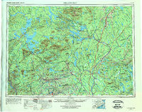
~ Millinocket ME topo map, 1:250000 scale, 1 X 2 Degree, Historical, 1954, updated 1975
Millinocket, Maine, USGS topographic map dated 1954.
Includes geographic coordinates (latitude and longitude). This topographic map is suitable for hiking, camping, and exploring, or framing it as a wall map.
Printed on-demand using high resolution imagery, on heavy weight and acid free paper, or alternatively on a variety of synthetic materials.
Topos available on paper, Waterproof, Poly, or Tyvek. Usually shipping rolled, unless combined with other folded maps in one order.
- Product Number: USGS-5537459
- Free digital map download (high-resolution, GeoPDF): Millinocket, Maine (file size: 17 MB)
- Map Size: please refer to the dimensions of the GeoPDF map above
- Weight (paper map): ca. 55 grams
- Map Type: POD USGS Topographic Map
- Map Series: HTMC
- Map Verison: Historical
- Cell ID: 75021
- Scan ID: 806906
- Imprint Year: 1975
- Woodland Tint: Yes
- Edit Year: 1967
- Field Check Year: 1954
- Datum: Unstated
- Map Projection: Transverse Mercator
- Map published by United States Army Corps of Engineers
- Map published by United States Army
- Map Language: English
- Scanner Resolution: 508 dpi
- Map Cell Name: Millinocket
- Grid size: 1 X 2 Degree
- Date on map: 1954
- Map Scale: 1:250000
- Geographical region: Maine, United States
Neighboring Maps:
All neighboring USGS topo maps are available for sale online at a variety of scales.
Spatial coverage:
Topo map Millinocket, Maine, covers the geographical area associated the following places:
- East Winn - Medway - Derby - Charleston - Durbin Corner - Chester - Pleasant Pond - Pingree Center - Stacyville - Parrot - Moosehead - Rollins Mill - Lincoln - North Dexter - Packard Landing - North Bradford - East Sangerville - Norcross - Crystal - Monarda - Sebec Corners - Macwahoc - Gordon (historical) - North East Carry - Millinocket - The Forks - Abbot Village - Moscow - East Dover - Berrys Corner - Upper Drew - Dolby - Willimantic - Sebec Lake - Carroll - Mill Brook - Parkers - Brassua - Burdin Corner - Gerry - Silvers Mills - Dunham Corner - East Millinocket - Upper Abbot - Saponac - Goodell Corner - Crockertown - Hutchins Corner - Hurd Corner - Alton - Little Italy - Garland - Gilford - Bowerbank (historical) - High Landing - Pea Ridge - Carr Corner - Sangerville - Howard Corner - Oak Park Manor - Wellington - Knight Corner - Packards - Benson - Schoodic - Kingsbury - Goffs Corner - Lincoln Center - Argyle - Shirley Mills - Hicks Corner - East Lowell - Lowell - Sherman Mills - Lee - Molunkus - Cambridge - Lake Moxie - Cardville - Greeleys Landing - North Guilford - Greenville - Prentiss - South Lincoln - Somerset Junction - Dover-Foxcroft - Johnson Corner - Lily Bay - Greenville Junction - Benedicta - Hudson - Olamon - Edes Corner - Seboeis - Reed - Glenwood - Howland - Hay Brook - Enfield - Starbirds
- Map Area ID: AREA4645-70-68
- Northwest corner Lat/Long code: USGSNW46-70
- Northeast corner Lat/Long code: USGSNE46-68
- Southwest corner Lat/Long code: USGSSW45-70
- Southeast corner Lat/Long code: USGSSE45-68
- Northern map edge Latitude: 46
- Southern map edge Latitude: 45
- Western map edge Longitude: -70
- Eastern map edge Longitude: -68


