
~ Lewiston ME topo map, 1:250000 scale, 1 X 2 Degree, Historical, 1962, updated 1962
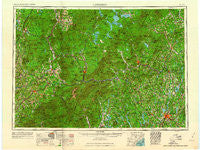
Lewiston, Maine, USGS topographic map dated 1962.
Includes geographic coordinates (latitude and longitude). This topographic map is suitable for hiking, camping, and exploring, or framing it as a wall map.
Printed on-demand using high resolution imagery, on heavy weight and acid free paper, or alternatively on a variety of synthetic materials.
Topos available on paper, Waterproof, Poly, or Tyvek. Usually shipping rolled, unless combined with other folded maps in one order.
- Product Number: USGS-5537457
- Free digital map download (high-resolution, GeoPDF): Lewiston, Maine (file size: 18 MB)
- Map Size: please refer to the dimensions of the GeoPDF map above
- Weight (paper map): ca. 55 grams
- Map Type: POD USGS Topographic Map
- Map Series: HTMC
- Map Verison: Historical
- Cell ID: 75018
- Scan ID: 806839
- Imprint Year: 1962
- Woodland Tint: Yes
- Field Check Year: 1956
- Survey Year: 1956
- Datum: Unstated
- Map Projection: Transverse Mercator
- Map published by United States Army Corps of Engineers
- Map published by United States Army
- Map Language: English
- Scanner Resolution: 508 dpi
- Map Cell Name: Lewiston
- Grid size: 1 X 2 Degree
- Date on map: 1962
- Map Scale: 1:250000
- Geographical region: Maine, United States
Neighboring Maps:
All neighboring USGS topo maps are available for sale online at a variety of scales.
Spatial coverage:
Topo map Lewiston, Maine, covers the geographical area associated the following places:
- Fish Street - East Conway - West Burke - Fayette - West Bridgton - Canton Point - Dixville Notch - Pleasant Island - Riley - East Charleston - Bolsters Mills - East Burke - Whitefield - Wales Corner - North Bethel - Buckfield - Farmington Falls - Meriden Hill - Barrett - East Concord - Drinkwater Corner - East Brighton - East Sweden - Shy Corner - Dallas - Mountain Lakes - West Leeds - Wenlock - Goodrich Corner - Highlands - Sodom - Rumford Point - Rowe Corner - Fairview - Northwest Bethel - Carthage - Shelburne - Harmons Corner - Dixfield - Leeds - New Auburn - Dickvale - Milton - Colebrook - Slab City - North Buckfield - Victory - Wentworth Location - Tainter Corner - Fabyan - East Otisfield - Dalton - Webster Corner - Chisholm - Gilman Mobile Park - Blake Corner - Gorham - Stones Corner - Redstone - Brimstone Corner - Oak Hill - Bryant Pond - Bemis - Weeks Mills - East Livermore - Greenwood - Canton - Rogers Crossing - Columbia - Skillings Corner - East Haven - Mapleton - Guildhall - Rangeley - South Rangeley - Smith Crossing - Soule Mill - North Conway - Bullthroat - Rayville - Lisbon - West Mount Vernon - Coreys Mobile Park - Mayville - Scribners Mill - Berry Mills - Avon - Marshfield Station - Oxford Station - Allens Mills - Auburn Plains - Swiftwater - Turner - Murphy Corner - Temple - Promised Land - Lisbon Center - Strong - Liberty Corner - Hildreths Mill
- Map Area ID: AREA4544-72-70
- Northwest corner Lat/Long code: USGSNW45-72
- Northeast corner Lat/Long code: USGSNE45-70
- Southwest corner Lat/Long code: USGSSW44-72
- Southeast corner Lat/Long code: USGSSE44-70
- Northern map edge Latitude: 45
- Southern map edge Latitude: 44
- Western map edge Longitude: -72
- Eastern map edge Longitude: -70


