
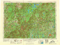
~ Lewiston ME topo map, 1:250000 scale, 1 X 2 Degree, Historical, 1969, updated 1969
Lewiston, Maine, USGS topographic map dated 1969.
Includes geographic coordinates (latitude and longitude). This topographic map is suitable for hiking, camping, and exploring, or framing it as a wall map.
Printed on-demand using high resolution imagery, on heavy weight and acid free paper, or alternatively on a variety of synthetic materials.
Topos available on paper, Waterproof, Poly, or Tyvek. Usually shipping rolled, unless combined with other folded maps in one order.
- Product Number: USGS-5537455
- Free digital map download (high-resolution, GeoPDF): Lewiston, Maine (file size: 18 MB)
- Map Size: please refer to the dimensions of the GeoPDF map above
- Weight (paper map): ca. 55 grams
- Map Type: POD USGS Topographic Map
- Map Series: HTMC
- Map Verison: Historical
- Cell ID: 75018
- Scan ID: 806838
- Imprint Year: 1969
- Woodland Tint: Yes
- Field Check Year: 1956
- Datum: Unstated
- Map Projection: Transverse Mercator
- Map published by United States Army Corps of Engineers
- Map published by United States Army
- Map Language: English
- Scanner Resolution: 508 dpi
- Map Cell Name: Lewiston
- Grid size: 1 X 2 Degree
- Date on map: 1969
- Map Scale: 1:250000
- Geographical region: Maine, United States
Neighboring Maps:
All neighboring USGS topo maps are available for sale online at a variety of scales.
Spatial coverage:
Topo map Lewiston, Maine, covers the geographical area associated the following places:
- East Hebron - Gateway Trailer Park - Rumford Junction - Fish Street - Scribners Mill - West Stewartstown - South Lewiston - Parker Hill - Notchland - Weeks Mills - Oxford - Lewiston Junction - East Auburn - Center Minot - Danville - North Waterford - Kidderville - Maplewood - Cones - East Conway - Goodrich Falls - Tinkerville - Brunswick Springs - South Leeds - Gilman - Danville Corner - Grange - Lexington - Norway Center - Fairbanks - Whitefield - Five Corners - Cooks Crossing - Mill Village - Lisbon - Oxford Station - Empire - North Bridgton - Wilton Intervale - Chase Corner - Butterfield (historical) - New Auburn - Errol - Bryant Pond - East Livermore - Littleton - Farmington - Goodrich Corner - Wilton - Harrison - Bullen Mills - North Leeds - Apthorp - Livermore - Riley - Worthley Pond - West Waterford - Keenes Corner - Slab City - Hackett Mills - Texas - Richmond Mill - Perham Junction - Bretton Woods - Meriden Hill - West Paris - Deerfield - North Norway - Waterford Flat - Chesterville - Burke Hollow - Wayne - Shy Corner - East Waterford - Wilsons Mills - Bethel - Arlins - Nason Beach - North Stratford - Caldwell Corner - East Otisfield - West Bethel - Fayette - North Woodstock - Foggs Corner - East Brighton - Baptist Hill - Sweden - Carroll - East Fryeburg - Poland Spring - Stuarts Corner - Rumford Center - Newry - Appalachia - Jay - North Chatham - Middle Intervale - Turner - Dixfield
- Map Area ID: AREA4544-72-70
- Northwest corner Lat/Long code: USGSNW45-72
- Northeast corner Lat/Long code: USGSNE45-70
- Southwest corner Lat/Long code: USGSSW44-72
- Southeast corner Lat/Long code: USGSSE44-70
- Northern map edge Latitude: 45
- Southern map edge Latitude: 44
- Western map edge Longitude: -72
- Eastern map edge Longitude: -70


