
~ Lewiston ME topo map, 1:250000 scale, 1 X 2 Degree, Historical, 1956, updated 1975
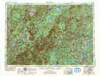
Lewiston, Maine, USGS topographic map dated 1956.
Includes geographic coordinates (latitude and longitude). This topographic map is suitable for hiking, camping, and exploring, or framing it as a wall map.
Printed on-demand using high resolution imagery, on heavy weight and acid free paper, or alternatively on a variety of synthetic materials.
Topos available on paper, Waterproof, Poly, or Tyvek. Usually shipping rolled, unless combined with other folded maps in one order.
- Product Number: USGS-5537453
- Free digital map download (high-resolution, GeoPDF): Lewiston, Maine (file size: 22 MB)
- Map Size: please refer to the dimensions of the GeoPDF map above
- Weight (paper map): ca. 55 grams
- Map Type: POD USGS Topographic Map
- Map Series: HTMC
- Map Verison: Historical
- Cell ID: 75018
- Scan ID: 806837
- Imprint Year: 1975
- Woodland Tint: Yes
- Aerial Photo Year: 1972
- Edit Year: 1972
- Field Check Year: 1956
- Datum: Unstated
- Map Projection: Transverse Mercator
- Map published by United States Geological Survey
- Map published by: Military, Other
- Map Language: English
- Scanner Resolution: 508 dpi
- Map Cell Name: Lewiston
- Grid size: 1 X 2 Degree
- Date on map: 1956
- Map Scale: 1:250000
- Geographical region: Maine, United States
Neighboring Maps:
All neighboring USGS topo maps are available for sale online at a variety of scales.
Spatial coverage:
Topo map Lewiston, Maine, covers the geographical area associated the following places:
- Overlake - North New Portland - Monmouth - Mapleton - Oxford Station - Avon - Wildwood - Swiftwater - Lost Nation - Skillings Corner - South Turner - Riley - Littleton - Nason Beach - Mittersill - Soule Mill - Jackson - Benton - Groveton - Livermore - Gateway Trailer Park - Lancaster - Fairbanks - Penley Corner - Rangeley - Bethlehem - East Brighton - Houghton - Twelve Corners - Deerfield - West Mount Vernon - Strong - East New Portland - Bungy - Byron - West Sumner - Hartwellville - North Chesterville - Pratt Corner - Stevens - Richmond Mill - MacQuillis Corner - Lower Bartlett - Lynchville - East Stoneham - Carroll - Dixville Notch - North Kirby - Weeks Mills - Sawyers River - Redstone - Kingfield - East Haven - Randolph - Dunkertown - Plummer Landing - Baileys - North Wayne - Redington - West Farmington - South Rumford - The Hand - Ridlonville - Madrid - Colebrook - Granby - Nobles Corner - Scates Corner - East Lyndon - West Stewartstown - Milan - North Auburn - Bemis - Bethel - Sugar Hill - Greene Corner - Hildreths Mill - South Lancaster - Chase Mills - Panno Place - South Chatham - Haines Corner - Fryeburg - Littlefield Corner - Hackett Mills - Dixfield Center - Barrett - Scribners Mill - Ketchum - Whitefield - Maidstone - Browns Mill - Center Lovell - Hebron - Lincoln - Hartford - New Vineyard - West Milan - Cushman - Redding
- Map Area ID: AREA4544-72-70
- Northwest corner Lat/Long code: USGSNW45-72
- Northeast corner Lat/Long code: USGSNE45-70
- Southwest corner Lat/Long code: USGSSW44-72
- Southeast corner Lat/Long code: USGSSE44-70
- Northern map edge Latitude: 45
- Southern map edge Latitude: 44
- Western map edge Longitude: -72
- Eastern map edge Longitude: -70


