
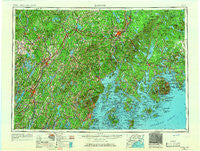
~ Bangor ME topo map, 1:250000 scale, 1 X 2 Degree, Historical, 1956, updated 1966
Bangor, Maine, USGS topographic map dated 1956.
Includes geographic coordinates (latitude and longitude). This topographic map is suitable for hiking, camping, and exploring, or framing it as a wall map.
Printed on-demand using high resolution imagery, on heavy weight and acid free paper, or alternatively on a variety of synthetic materials.
Topos available on paper, Waterproof, Poly, or Tyvek. Usually shipping rolled, unless combined with other folded maps in one order.
- Product Number: USGS-5537429
- Free digital map download (high-resolution, GeoPDF): Bangor, Maine (file size: 18 MB)
- Map Size: please refer to the dimensions of the GeoPDF map above
- Weight (paper map): ca. 55 grams
- Map Type: POD USGS Topographic Map
- Map Series: HTMC
- Map Verison: Historical
- Cell ID: 68662
- Scan ID: 806481
- Imprint Year: 1966
- Woodland Tint: Yes
- Edit Year: 1965
- Survey Year: 1956
- Datum: Unstated
- Map Projection: Transverse Mercator
- Map published by United States Army Corps of Engineers
- Map published by United States Army
- Map Language: English
- Scanner Resolution: 508 dpi
- Map Cell Name: Bangor
- Grid size: 1 X 2 Degree
- Date on map: 1956
- Map Scale: 1:250000
- Geographical region: Maine, United States
Neighboring Maps:
All neighboring USGS topo maps are available for sale online at a variety of scales.
Spatial coverage:
Topo map Bangor, Maine, covers the geographical area associated the following places:
- East Knox - Glendon - Wildwood - Belfast - Five Mile Corners - Martells Mobile Home Court - Larone - Blackinton Corners - Mitchell Corner - North Dixmont - Goodwin Siding - Gould Corner - North Newport - Indian Point - Frenchboro - Pelton Hill - Turners Corner - North Whitefield - Winterport - Solon - Hampden Station - Paines Corner - Otter Creek - Mitchell Corner - Bass Harbor - Cold Brook - Northern Maine Junction - Head of the Tide - North Brewer - Lakeside Landing - Nickerson Mills - Holiday Beach - Canaan - Cass Corner - Burkettville - North Hope Corner - Bernard - Temple Heights - Cooks Corner - Thorndike - Naskeag - Palermo - Stetson - Stockton Springs - North Monroe - Willis Corners - Hurds Corner - Hall Quarry - Lambs Corner - Decker Corner - Snow Corner - West Athens - Johnson Corner - Tyler Corner - East Orland - South Gardiner - North Vassalboro - Brown Corner - Northport - Marsh Corner - Martins Corner - Brewer - Arnolds Landing - Rome Corner - Greenlaws Corner - Hampden Center - Swans Island - Riverside - West Montville - Franklin Road - Kalers Corner - Island Park - China - Bucksport Center - Troy Center - Halls Corner - North Jefferson - Steep Landing - Orono - Eden - Mountainville - Farmingdale - North Deer Isle - Mosher Corner - Otis - Leathers Corner - Yorks Corner - Appleton - Lyford Corner - North Windsor - North Searsmont - Rockville - Hope - Walker Corner - South Deer Isle - West Glenburn - Dane Corner - South Newburgh - Payson Corner - Stevens Corner
- Map Area ID: AREA4544-70-68
- Northwest corner Lat/Long code: USGSNW45-70
- Northeast corner Lat/Long code: USGSNE45-68
- Southwest corner Lat/Long code: USGSSW44-70
- Southeast corner Lat/Long code: USGSSE44-68
- Northern map edge Latitude: 45
- Southern map edge Latitude: 44
- Western map edge Longitude: -70
- Eastern map edge Longitude: -68


