
~ Bangor ME topo map, 1:250000 scale, 1 X 2 Degree, Historical, 1956, updated 1973
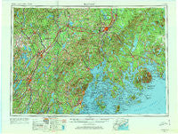
Bangor, Maine, USGS topographic map dated 1956.
Includes geographic coordinates (latitude and longitude). This topographic map is suitable for hiking, camping, and exploring, or framing it as a wall map.
Printed on-demand using high resolution imagery, on heavy weight and acid free paper, or alternatively on a variety of synthetic materials.
Topos available on paper, Waterproof, Poly, or Tyvek. Usually shipping rolled, unless combined with other folded maps in one order.
- Product Number: USGS-5537427
- Free digital map download (high-resolution, GeoPDF): Bangor, Maine (file size: 18 MB)
- Map Size: please refer to the dimensions of the GeoPDF map above
- Weight (paper map): ca. 55 grams
- Map Type: POD USGS Topographic Map
- Map Series: HTMC
- Map Verison: Historical
- Cell ID: 68662
- Scan ID: 806480
- Imprint Year: 1973
- Woodland Tint: Yes
- Edit Year: 1965
- Field Check Year: 1956
- Datum: Unstated
- Map Projection: Transverse Mercator
- Map published by United States Army Corps of Engineers
- Map published by United States Army
- Map Language: English
- Scanner Resolution: 508 dpi
- Map Cell Name: Bangor
- Grid size: 1 X 2 Degree
- Date on map: 1956
- Map Scale: 1:250000
- Geographical region: Maine, United States
Neighboring Maps:
All neighboring USGS topo maps are available for sale online at a variety of scales.
Spatial coverage:
Topo map Bangor, Maine, covers the geographical area associated the following places:
- Goodwin Corner - Amherst - Bailey Corner - West Deer Isle - Miles Corner - Unity - Benner Corner - Billings Hill - Fairfield Center - Spragues Mill - Ripley - Shermans Corner - North Palermo - Stillwater - Wiscasset - Davis Corner - Clarks Corner - Mariaville - Mitchell Corner - Double A Landing - South Gouldsboro - Farwells Corner - Asticou - South Surry - Arnolds Landing - Head Tide - South Blue Hill - Wings Mills - Bremen - Holiday Beach - Seaward Mills - McCoy Crossing - White School Corner - Moody - Embden - East Hampden - Waterville - Dresden Mills - Ash Point - Knox Center - Archers Corners - Locks Corner - Drake Corner - Greens Corner - Saint Albans - Cranes Corners - Basin Mills - Union - Stetson - Richtown - Belfast - West Brooklin - Trainor Corner - Ellsworth - Bass Harbor - Isle Au Haut - Hartland - Cornville - Arnold Corner - West Tremont - Franklin - Starbird Corner - Smithton - West Surry - Camden - Melvin Heights - Burkettville - North Monroe - Damariscotta - Knox Hill Corner - Poors Mill - Martells Mobile Home Court - Waldoboro - Richmond - Winterport - Chelsea - East Dixmont - North Searsport - Wonderland - Leathers Corner - Little Deer Isle - East Benton - Hermon - Sandy Point - Green Lake - Nash Corner - Turners Corner - Todds Corner - Etna Center - South Corinth - Togus - Knox Ledge Corner - Stovers Corner - Pease Corner - Windsorville - Norumbega - North Fairfield - Batchelders Crossing - Myra - Franklin Road
- Map Area ID: AREA4544-70-68
- Northwest corner Lat/Long code: USGSNW45-70
- Northeast corner Lat/Long code: USGSNE45-68
- Southwest corner Lat/Long code: USGSSW44-70
- Southeast corner Lat/Long code: USGSSE44-68
- Northern map edge Latitude: 45
- Southern map edge Latitude: 44
- Western map edge Longitude: -70
- Eastern map edge Longitude: -68


