
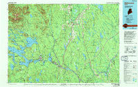
~ Millinocket ME topo map, 1:100000 scale, 30 X 60 Minute, Historical, 1985, updated 1994
Millinocket, Maine, USGS topographic map dated 1985.
Includes geographic coordinates (latitude and longitude). This topographic map is suitable for hiking, camping, and exploring, or framing it as a wall map.
Printed on-demand using high resolution imagery, on heavy weight and acid free paper, or alternatively on a variety of synthetic materials.
Topos available on paper, Waterproof, Poly, or Tyvek. Usually shipping rolled, unless combined with other folded maps in one order.
- Product Number: USGS-5537393
- Free digital map download (high-resolution, GeoPDF): Millinocket, Maine (file size: 27 MB)
- Map Size: please refer to the dimensions of the GeoPDF map above
- Weight (paper map): ca. 55 grams
- Map Type: POD USGS Topographic Map
- Map Series: HTMC
- Map Verison: Historical
- Cell ID: 67959
- Scan ID: 808086
- Imprint Year: 1994
- Woodland Tint: Yes
- Photo Inspection Year: 1992
- Aerial Photo Year: 1980
- Edit Year: 1985
- Datum: NAD27
- Map Projection: Universal Transverse Mercator
- Map published by United States Geological Survey
- Map Language: English
- Scanner Resolution: 508 dpi
- Map Cell Name: Millinocket
- Grid size: 30 X 60 Minute
- Date on map: 1985
- Map Scale: 1:100000
- Geographical region: Maine, United States
Neighboring Maps:
All neighboring USGS topo maps are available for sale online at a variety of scales.
Spatial coverage:
Topo map Millinocket, Maine, covers the geographical area associated the following places:
- Sherman Station - West Seboeis - Perkins - Davidson (historical) - Medway - Norcross - New City - Dolby - Kingman - Bancroft - Mattawamkeag - Upper Drew - Macwahoc - Stacyville - Hay Brook - Patten - Grindstone - Glenwood - Patten Junction - Molunkus - Stephensons Landing - Gordon (historical) - Gantners Landing - Silver Ridge - Wytopitlock - High Landing - City Camp Landing - Back Settlement - Crystal - Bowden (historical) - Meadowville - Reed - Siberia - Silverwood Court - Sherman - Jordan Mills - Webb Hill - Benedicta - Sherman Mills - Little Italy - Millinocket - Monarda - Oak Park Manor - East Millinocket - Woodbridge Corner
- Map Area ID: AREA4645.5-69-68
- Northwest corner Lat/Long code: USGSNW46-69
- Northeast corner Lat/Long code: USGSNE46-68
- Southwest corner Lat/Long code: USGSSW45.5-69
- Southeast corner Lat/Long code: USGSSE45.5-68
- Northern map edge Latitude: 46
- Southern map edge Latitude: 45.5
- Western map edge Longitude: -69
- Eastern map edge Longitude: -68


