
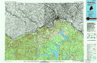
~ Madawaska ME topo map, 1:100000 scale, 30 X 60 Minute, Historical, 1994, updated 1994
Madawaska, Maine, USGS topographic map dated 1994.
Includes geographic coordinates (latitude and longitude). This topographic map is suitable for hiking, camping, and exploring, or framing it as a wall map.
Printed on-demand using high resolution imagery, on heavy weight and acid free paper, or alternatively on a variety of synthetic materials.
Topos available on paper, Waterproof, Poly, or Tyvek. Usually shipping rolled, unless combined with other folded maps in one order.
- Product Number: USGS-5537383
- Free digital map download (high-resolution, GeoPDF): Madawaska, Maine (file size: 32 MB)
- Map Size: please refer to the dimensions of the GeoPDF map above
- Weight (paper map): ca. 55 grams
- Map Type: POD USGS Topographic Map
- Map Series: HTMC
- Map Verison: Historical
- Cell ID: 76824
- Scan ID: 808054
- Imprint Year: 1994
- Woodland Tint: Yes
- Aerial Photo Year: 1991
- Edit Year: 1994
- Datum: NAD27
- Map Projection: Universal Transverse Mercator
- Map published by United States Geological Survey
- Map Language: English
- Scanner Resolution: 508 dpi
- Map Cell Name: Madawaska
- Grid size: 30 X 60 Minute
- Date on map: 1994
- Map Scale: 1:100000
- Geographical region: Maine, United States
Neighboring Maps:
All neighboring USGS topo maps are available for sale online at a variety of scales.
Spatial coverage:
Topo map Madawaska, Maine, covers the geographical area associated the following places:
- Plaisted - Bradbury - Fournier - Daigle - Carriveau Mill - Ouellette - Saint David - Fort Kent Village - Burnt Mill - Burnt Landing - Bradburys - Sinclair - Grand Isle - Lille - Daigle Mill - Guerette - Soldier Pond - Cross Rock - California - Parent - Pierre - Madawaska - Notre Dame - Fort Kent - Cleveland - Eagle Lake - Upper Frenchville - Wheelock - Jones Mill - Jemtland - Saint Agatha - Frenchville - Stockholm - Violette Settlement - Plourde Mill - Lavertue - Michigan Settlement - Wallagrass - Saint Francis - Back Settlement - Fort Kent Mills - Saint John
- Map Area ID: AREA47.547-69-68
- Northwest corner Lat/Long code: USGSNW47.5-69
- Northeast corner Lat/Long code: USGSNE47.5-68
- Southwest corner Lat/Long code: USGSSW47-69
- Southeast corner Lat/Long code: USGSSE47-68
- Northern map edge Latitude: 47.5
- Southern map edge Latitude: 47
- Western map edge Longitude: -69
- Eastern map edge Longitude: -68


