
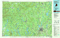
~ Lewiston ME topo map, 1:100000 scale, 30 X 60 Minute, Historical, 1986, updated 1988
Lewiston, Maine, USGS topographic map dated 1986.
Includes geographic coordinates (latitude and longitude). This topographic map is suitable for hiking, camping, and exploring, or framing it as a wall map.
Printed on-demand using high resolution imagery, on heavy weight and acid free paper, or alternatively on a variety of synthetic materials.
Topos available on paper, Waterproof, Poly, or Tyvek. Usually shipping rolled, unless combined with other folded maps in one order.
- Product Number: USGS-5537371
- Free digital map download (high-resolution, GeoPDF): Lewiston, Maine (file size: 27 MB)
- Map Size: please refer to the dimensions of the GeoPDF map above
- Weight (paper map): ca. 55 grams
- Map Type: POD USGS Topographic Map
- Map Series: HTMC
- Map Verison: Historical
- Cell ID: 67840
- Scan ID: 808019
- Imprint Year: 1988
- Woodland Tint: Yes
- Photo Inspection Year: 1988
- Aerial Photo Year: 1981
- Edit Year: 1986
- Datum: NAD27
- Map Projection: Universal Transverse Mercator
- Map published by United States Geological Survey
- Map Language: English
- Scanner Resolution: 508 dpi
- Map Cell Name: Lewiston
- Grid size: 30 X 60 Minute
- Date on map: 1986
- Map Scale: 1:100000
- Geographical region: Maine, United States
Neighboring Maps:
All neighboring USGS topo maps are available for sale online at a variety of scales.
Spatial coverage:
Topo map Lewiston, Maine, covers the geographical area associated the following places:
- Lewiston - East Sumner - Bethel - Gould Corner - Murphy Corner - Turner Center - Livermore Falls - Hartford - East Waterford - North Leeds - South Turner - Hunts Corner - West Leeds - Northwest Bethel - Newry - Dickvale - Welchville - Shy Corner - Meadowview - Rayville - Paine Corner - West Auburn - Poland Spring - Rumford Corner - Wales Corner - East Wales - North Waterford - Curtis Corner - Auburn Plains - Locke Mills - Otisfield Gore - East Poland - Merrow Landing - Penley Corner - Turner - West Fryeburg - Keens Mills - Greenwood - Canton Point - Yagger - Liberty Corner - North Turner - Casco - West Paris - Worthley Pond - Harrison - Royal Corner - East Buckfield - North Buckfield - North Wayne - Oxford - Trap Corner - West Bowdoin - Haskell Corner - Wight Corners - Nason Beach - East Bethel - Livermore - Skillings Corner - East Auburn - Leeds - Lovell - West Sumner - Twelve Corners - Auburn - Gilbertville - North Monmouth - Bolsters Mills - Willis Mill - Oak Hill - Chambers Corner - Mechanic Falls - North Livermore - Chisholm - Gilead - Sandy Creek - Center Lovell - South Paris - Sweden - Hebron - Bryant Pond - North Bethel - East Sweden - Richmond Mill - Stow - North Norway - Lisbon Center - Pratt Corner - Stricklands - Lewiston Junction - North Auburn - Five Corners - South Waterford - West Mount Vernon - Stuarts Corner - Bridgton - New Auburn - Caldwell Corner - Littlefield Corner - South Poland
- Map Area ID: AREA44.544-71-70
- Northwest corner Lat/Long code: USGSNW44.5-71
- Northeast corner Lat/Long code: USGSNE44.5-70
- Southwest corner Lat/Long code: USGSSW44-71
- Southeast corner Lat/Long code: USGSSE44-70
- Northern map edge Latitude: 44.5
- Southern map edge Latitude: 44
- Western map edge Longitude: -71
- Eastern map edge Longitude: -70


