
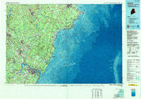
~ Kittery ME topo map, 1:100000 scale, 30 X 60 Minute, Historical, 1985, updated 1989
Kittery, Maine, USGS topographic map dated 1985.
Includes geographic coordinates (latitude and longitude). This topographic map is suitable for hiking, camping, and exploring, or framing it as a wall map.
Printed on-demand using high resolution imagery, on heavy weight and acid free paper, or alternatively on a variety of synthetic materials.
Topos available on paper, Waterproof, Poly, or Tyvek. Usually shipping rolled, unless combined with other folded maps in one order.
- Product Number: USGS-5537363
- Free digital map download (high-resolution, GeoPDF): Kittery, Maine (file size: 28 MB)
- Map Size: please refer to the dimensions of the GeoPDF map above
- Weight (paper map): ca. 55 grams
- Map Type: POD USGS Topographic Map
- Map Series: HTMC
- Map Verison: Historical
- Cell ID: 76818
- Scan ID: 808006
- Imprint Year: 1989
- Woodland Tint: Yes
- Aerial Photo Year: 1982
- Edit Year: 1985
- Datum: NAD27
- Map Projection: Universal Transverse Mercator
- Map published by United States Geological Survey
- Map Language: English
- Scanner Resolution: 508 dpi
- Map Cell Name: Kittery
- Grid size: 30 X 60 Minute
- Date on map: 1985
- Map Scale: 1:100000
- Geographical region: Maine, United States
Neighboring Maps:
All neighboring USGS topo maps are available for sale online at a variety of scales.
Spatial coverage:
Topo map Kittery, Maine, covers the geographical area associated the following places:
- West Rye - Shepherds Hill - Scotland - Clock Farm Corner - Acorn Acres - Greenland - North Rochester - South Sanford - Langs Corner - Shaws Hill - Hillcrest Estates - Guinea Corner - Emery Mills - Days Mill - Maplehaven - Biddeford - Berwick - Central Park - Blackwater - Clark Hill - Beech Ridge - Braeburn - Laskey Corner - Melrose Corner - Bald Hill Crossing - Greenland Station - Biddeford Pool - Briggs Corner - Coopers Corner - Somersworth - Hills Beach - Jewett - Wells - Wildes Corner - Lebanon - Moody Point - Bedell Crossing - Breakfast Hill - Rosemary - Moody Beach - Portsmouth Mobile Homes - Varney Crossing - Cain Crest Trailer Park - Rockingham - Wells Beach Station - Kennebunk - South Lebanon - Admiralty Village - North Berwick - Rye - Bay View - Christian Shore - Kennebunk Beach - Winnicut Mills - Tattle Corner - Lower Village - Newington - Portsmouth - Wentworth Terrace - Portsmouth Plains - Rollinsford Station - Oak Terrace - Scituate - Durham - Tea Kettle Corner - Green Acre - Alfred Mills - Adams Corner - Four Corners - Kennard Corner - Seabury - Oak Ridge - West Lebanon - Brixham Lower Corners - Bayside - South Side - Buffum Hill - Clay Hill - Kinney Shores - Hobbs Crossing - Cider Hill - Pickering - York Corner - Rollinsford - Turbats Creek - Colonial Pines - York Cliffs - Foundry - Gates Corner - Chases Pond - East Lebanon - Eliot - Grays Corner - East Eliot - Bersum Gardens - Parsonage Corner - Wells Branch - Ocean View Village - Foyes Corner - Pine Hill
- Map Area ID: AREA43.543-71-70
- Northwest corner Lat/Long code: USGSNW43.5-71
- Northeast corner Lat/Long code: USGSNE43.5-70
- Southwest corner Lat/Long code: USGSSW43-71
- Southeast corner Lat/Long code: USGSSE43-70
- Northern map edge Latitude: 43.5
- Southern map edge Latitude: 43
- Western map edge Longitude: -71
- Eastern map edge Longitude: -70


