
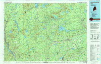
~ Dover Foxcroft ME topo map, 1:100000 scale, 30 X 60 Minute, Historical, 1994, updated 1994
Dover Foxcroft, Maine, USGS topographic map dated 1994.
Includes geographic coordinates (latitude and longitude). This topographic map is suitable for hiking, camping, and exploring, or framing it as a wall map.
Printed on-demand using high resolution imagery, on heavy weight and acid free paper, or alternatively on a variety of synthetic materials.
Topos available on paper, Waterproof, Poly, or Tyvek. Usually shipping rolled, unless combined with other folded maps in one order.
- Product Number: USGS-5537349
- Free digital map download (high-resolution, GeoPDF): Dover Foxcroft, Maine (file size: 23 MB)
- Map Size: please refer to the dimensions of the GeoPDF map above
- Weight (paper map): ca. 55 grams
- Map Type: POD USGS Topographic Map
- Map Series: HTMC
- Map Verison: Historical
- Cell ID: 67434
- Scan ID: 807884
- Imprint Year: 1994
- Woodland Tint: Yes
- Aerial Photo Year: 1992
- Edit Year: 1994
- Datum: NAD27
- Map Projection: Universal Transverse Mercator
- Map published by United States Geological Survey
- Map Language: English
- Scanner Resolution: 508 dpi
- Map Cell Name: Dover-Foxcroft
- Grid size: 30 X 60 Minute
- Date on map: 1994
- Map Scale: 1:100000
- Geographical region: Maine, United States
Neighboring Maps:
All neighboring USGS topo maps are available for sale online at a variety of scales.
Spatial coverage:
Topo map Dover Foxcroft, Maine, covers the geographical area associated the following places:
- Brighton - Preble Corner - Bingham - Mayfield Corner - Greenville - Russell Corner - Kingsbury - Earnest Corner - East Dover - Monson Junction - Dexter - Pleasant Pond - Sebec - Upper Abbot - Morkill - Spooners Mill - Atkinson Mills - Goodell Corner - The Forks - West Charleston - Sebec Corners - Blanchard - Happy Corner - Jackman Corner - Mill Brook - Charleston - Gordon Corner - Troutdale - Onawa - Rollins Mill - Brownville - Abbot Village - Lower Shirley Corner - Barnard Corner - Earley Landing - Hurd Corner - East Sangerville - Hutchins Corner - Twin Brook - Caratunk - Monson - Starbirds - Berrys Corner - West Dover - Garland - The Highlands - Haseltine Corner - Benson - South Sebec - Sangerville - Guilford - Upper Shirley Corner - Gilman Corner - Goffs Corner - Guilford Center - Cole Corner - Parson Landing - Prairie - Durbin Corner - Dover South Mills - Bowerbank - Pingree Center - Howard Corner - Sebec Lake - Coolidge Corner - East Corinth - South Dover - Burdin Corner - Williamsburg - Steadman Landing - Deadwater - Willimantic - Carr Corner - Packard Landing - Parkman - Edes Corner - Parrot - Barnard - Shirley Mills - Bodfish - Lake Moxie - Brownville Junction - Dover-Foxcroft - Wellington - Moscow - Hicks Corner - Moody Corner - Johnson Corner - North Guilford - North Dexter - Huff Corner - Dunham Corner - Greeleys Landing - Mooresville - Silvers Mills - Knight Corner - Greenville Junction - Oliver Hill Corner - Cambridge - Moosehorn
- Map Area ID: AREA45.545-70-69
- Northwest corner Lat/Long code: USGSNW45.5-70
- Northeast corner Lat/Long code: USGSNE45.5-69
- Southwest corner Lat/Long code: USGSSW45-70
- Southeast corner Lat/Long code: USGSSE45-69
- Northern map edge Latitude: 45.5
- Southern map edge Latitude: 45
- Western map edge Longitude: -70
- Eastern map edge Longitude: -69


