
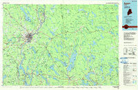
~ Bangor ME topo map, 1:100000 scale, 30 X 60 Minute, Historical, 1985, updated 1985
Bangor, Maine, USGS topographic map dated 1985.
Includes geographic coordinates (latitude and longitude). This topographic map is suitable for hiking, camping, and exploring, or framing it as a wall map.
Printed on-demand using high resolution imagery, on heavy weight and acid free paper, or alternatively on a variety of synthetic materials.
Topos available on paper, Waterproof, Poly, or Tyvek. Usually shipping rolled, unless combined with other folded maps in one order.
- Product Number: USGS-5537325
- Free digital map download (high-resolution, GeoPDF): Bangor, Maine (file size: 21 MB)
- Map Size: please refer to the dimensions of the GeoPDF map above
- Weight (paper map): ca. 55 grams
- Map Type: POD USGS Topographic Map
- Map Series: HTMC
- Map Verison: Historical
- Cell ID: 76777
- Scan ID: 807769
- Imprint Year: 1985
- Woodland Tint: Yes
- Aerial Photo Year: 1983
- Edit Year: 1985
- Datum: NAD27
- Map Projection: Universal Transverse Mercator
- Planimetric: Yes
- Map published by United States Geological Survey
- Map Language: English
- Scanner Resolution: 508 dpi
- Map Cell Name: Bangor
- Grid size: 30 X 60 Minute
- Date on map: 1985
- Map Scale: 1:100000
- Geographical region: Maine, United States
Neighboring Maps:
All neighboring USGS topo maps are available for sale online at a variety of scales.
Spatial coverage:
Topo map Bangor, Maine, covers the geographical area associated the following places:
- Eddington - Arey - North Searsport - Hampden - Dow Pines - Frankfort - Clifton - Nealeys Corner - Villa Vaughn - West Surry - Egypt - Cold Brook - Fowler Landing - Hardy Hill - South Brewer - Ellingwood Corner - Bucksport - Aurora - Swanville - Schoodic - Orrington Center - Eastbrook - Wilson Corner - East Bangor - Lucerne-in-Maine - Brown Corner - West Bangor - Deblois - Hampden Center - Orland - Franklin - Washington Junction - Goodale Corner - Double A Landing - Old Town Landing - Lakeside Landing - Joyville - Milford - South Orrington - North Hermon - Prospect Ferry - Six Mile Falls - Mariaville - Sand Beach - Veazie - Bradley - Millvale - North Orrington - Archers Corners - French Settlement - Hancock - Tunk Lake - Levant - Dedham - Verona - West Winterport - Kenduskeag - Dog Corners - Elliot Landing - North Mariaville - Orrington - East Franklin - East Orland - West Sullivan - East Bucksport - Webster - Sandy Point - Lakewood - West Ellsworth - Five Mile Corners - Great Pond - Sullivan - Green Lake - Rainbow Home Court Mobile Home Park - Steep Landing - Birch Hill Mobile Home Park - Hampden Station - West Old Town - Otis - Leathers Corner - Dodge Corner - Prospect - West Hampden - North Winterport - Glenburn Center - East Orrington - Higginsville - East Sullivan - Pushaw - Ellsworth - Northern Maine Junction - Orono - East Hampden - Hermon - Brewer - Basin Mills - North Bucksport - Whites Corner - Hurds Corner - South Hancock
- Map Area ID: AREA4544.5-69-68
- Northwest corner Lat/Long code: USGSNW45-69
- Northeast corner Lat/Long code: USGSNE45-68
- Southwest corner Lat/Long code: USGSSW44.5-69
- Southeast corner Lat/Long code: USGSSE44.5-68
- Northern map edge Latitude: 45
- Southern map edge Latitude: 44.5
- Western map edge Longitude: -69
- Eastern map edge Longitude: -68


