
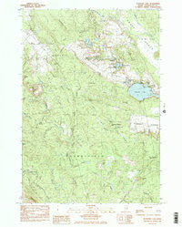
~ Schoodic Lake ME topo map, 1:24000 scale, 7.5 X 7.5 Minute, Historical, 1984, updated 1985
Schoodic Lake, Maine, USGS topographic map dated 1984.
Includes geographic coordinates (latitude and longitude). This topographic map is suitable for hiking, camping, and exploring, or framing it as a wall map.
Printed on-demand using high resolution imagery, on heavy weight and acid free paper, or alternatively on a variety of synthetic materials.
Topos available on paper, Waterproof, Poly, or Tyvek. Usually shipping rolled, unless combined with other folded maps in one order.
- Product Number: USGS-5535185
- Free digital map download (high-resolution, GeoPDF): Schoodic Lake, Maine (file size: 13 MB)
- Map Size: please refer to the dimensions of the GeoPDF map above
- Weight (paper map): ca. 55 grams
- Map Type: POD USGS Topographic Map
- Map Series: HTMC
- Map Verison: Historical
- Cell ID: 71535
- Scan ID: 102947
- Imprint Year: 1985
- Woodland Tint: Yes
- Aerial Photo Year: 1976
- Edit Year: 1984
- Field Check Year: 1978
- Datum: NAD27
- Map Projection: Transverse Mercator
- Provisional map: Yes
- Map published by United States Geological Survey
- Map Language: English
- Scanner Resolution: 600 dpi
- Map Cell Name: Schoodic Lake
- Grid size: 7.5 X 7.5 Minute
- Date on map: 1984
- Map Scale: 1:24000
- Geographical region: Maine, United States
Neighboring Maps:
All neighboring USGS topo maps are available for sale online at a variety of scales.
Spatial coverage:
Topo map Schoodic Lake, Maine, covers the geographical area associated the following places:
- Corliss Swamp - Bog Stream - Spring Brook - Peaked Hill - Elisha Brook - Salmon Brook - Horseshoe Pond - Campbell Meadow Hill - Deblois Flight Strip - Sprague Falls - Schoodic Lake - MacHatton Brook - East Pike Brook Pond - Hornet Island - Blueberry Barrens - Thousand Hills - Crotch Camp Brook - Campbell Meadow - Ingersoll Branch - Lookout Hill - Big Brook - Schoodic Brook - Spring Hole Pond - Parker Hill - Trout Cove - Dorr Meadow Brook - Heath Brook - Great Falls Branch - Town of Deblois - Morse Cemetery - Fickett Brook - Corliss Brook - Poplar Hill - Spectacle Ponds - Beaver Meadow Brook - Pineo Pond - Steel Meadow Brook - Pineo Ridge - Little Falls - Schoodic Hill - Town of Cherryfield - Colson Brook - Middle Brook - West Pike Brook Pond - Lilly Pond - Lawrence Brook - Mic-Mac Pond - Daggett Brook - Hardwood Ridge
- Map Area ID: AREA44.7544.625-68-67.875
- Northwest corner Lat/Long code: USGSNW44.75-68
- Northeast corner Lat/Long code: USGSNE44.75-67.875
- Southwest corner Lat/Long code: USGSSW44.625-68
- Southeast corner Lat/Long code: USGSSE44.625-67.875
- Northern map edge Latitude: 44.75
- Southern map edge Latitude: 44.625
- Western map edge Longitude: -68
- Eastern map edge Longitude: -67.875


